[ Homepage ] [ Introduction ] [ Warning ] [ Ratings
] [ Ethics ] [ Feedback ] [ Updates
]
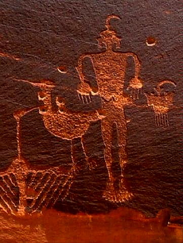 |
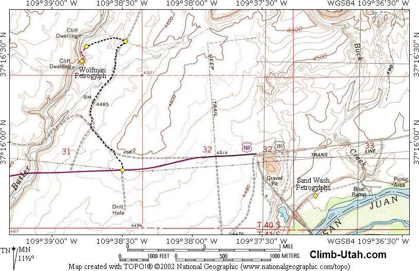
Wolfman Petroglyph
Panel
Cedar Mesa
Hiking
The
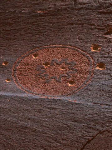
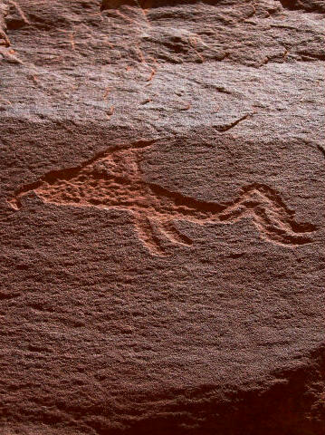
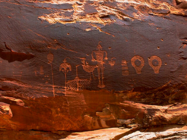
Wolfman Petroglyph Panel is easy for the entire family to enjoy. The panel contains
several dozen images that have been chipped into the sandstone cliff. |
General Information:
 The Wolfman Petroglyph Panel requires only a short walk. Please take only pictures and
leave only footprints. The Wolfman Petroglyph Panel contains several dozen images. A round
trip to visit and explore the panel will require approximately 30 minutes. The route is
only about 200 yards from the trailhead. The panel is accessible year round in good
weather.
The Wolfman Petroglyph Panel requires only a short walk. Please take only pictures and
leave only footprints. The Wolfman Petroglyph Panel contains several dozen images. A round
trip to visit and explore the panel will require approximately 30 minutes. The route is
only about 200 yards from the trailhead. The panel is accessible year round in good
weather.
A GPS is
extremely useful in verifying you are on the correct route. The area is criss crossed with
confusing roads and trails. The USGS 7.5' Map titled "Bluff SW" shows the area
described. The current roads are not shown correctly on the USGS map. Navigation for
this route is moderate. All waypoints and maps use the WGS84 datum. Wolfman Petroglyph is
rated 1A I using the Canyon Rating System.
Trailhead Information:
A high clearance vehicle is advised
for accessing this trailhead, four-wheel-drive is not required. A carefully driven
passenger car can usually access the trailhead in good weather.
From Bluff,
Utah travel west on Utah Highway 191 for 4 miles to the junction of Utah Highway 191 and
Utah Highway 163. Travel west 0.9 miles on Utah Highway 163 to a well maintained dirt
road on the north side of the highway (N37° 15' 50", W109° 38' 30"). This is
the Lower Butler Wash Road (SJC #262).
Turn north
onto the the dirt road. Follow the well maintained dirt road north for 1.0 miles to a
fence and a small track heading west (left). Passenger cars should park here. All others
drive west on the small track for 0.2 miles across the slickrock to the rim of the canyon.
This is the Wolfman Petroglyph Trailhead.
Route Information:
From the Wolfman Petroglyph
Trailhead (N37° 16' 33", W109° 38' 45") located on the rim of Butler Wash.
Look for cairns (small stacks of rock) that lead directly west over the edge to a wide
ledge. Walk to the south end of the ledge and you should find a place where you can
squeeze between a large rock and the cliff that allows access to the lower canyon. From
the bottom of the squeeze you should see a large alcove on the east (left) side of the
canyon. The Wolfman Petroglyph Panel (N37° 16' 28", W109° 38' 47") is located
on the south side of the alcove.
Additional Information:
Members of the Circle of Friends will find the additional Butler Wash Road information extremely valuable.
[
Homepage ] [ Introduction
] [ Warning ] [ Ratings ] [ Ethics ] [ Feedback
] [ Updates ]
© Copyright
2000-, Climb-Utah.com |