 Buckskin Gulch is best done as a two-day canyoneering and
backpacking adventure. The route can be done in one very long day. The route
is roughly 21 miles total, you will hike 13.5 miles on day one and 7.5 miles
on day two if completing the route as a two day trip. All waste must be packed out
of Buckskin Gulch and Paria Canyon. In less delicate terms, this means go prepared to
pack your poop.
Buckskin Gulch is best done as a two-day canyoneering and
backpacking adventure. The route can be done in one very long day. The route
is roughly 21 miles total, you will hike 13.5 miles on day one and 7.5 miles
on day two if completing the route as a two day trip. All waste must be packed out
of Buckskin Gulch and Paria Canyon. In less delicate terms, this means go prepared to
pack your poop.
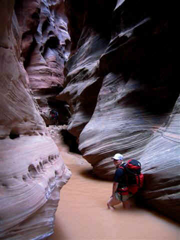
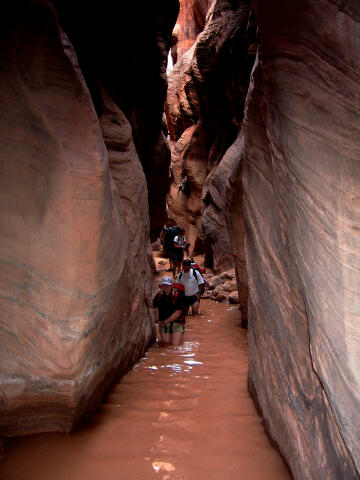
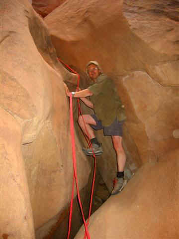
You will require a 40-foot rope for lowering backpacks and for possible use as a hand line. Scrambling is required in a few places. In normal conditions there are several miles of ankle deep wading and a few waist deep pools so wear appropriate footwear and clothing. An occasional swim is not unheard of. The pools can be very cold and are usually stagnant. I highly suggest you dry bag all items you want to keep dry. This canyon is rated 2B V using the Canyon Rating System. These canyons can be hiked year round except when thunderstorms are possible. Spring and Fall are the preferred hiking seasons. Hiking during the summer can be brutally hot. These canyons have a very high flash flood potential and caution should be used. Paria Canyon and its tributaries average eight flash floods a year. The canyon changes after every flash flood so go prepared. West Clark Bench, Bridger Point and Pine Hollow Canyon are the USGS 7.5 minute topographical maps that show Buckskin Gulch. Navigation for this adventure is easy, but there is no trail for the route. All waypoints and maps for this route use the WGS84 datum. Time
Requirements:
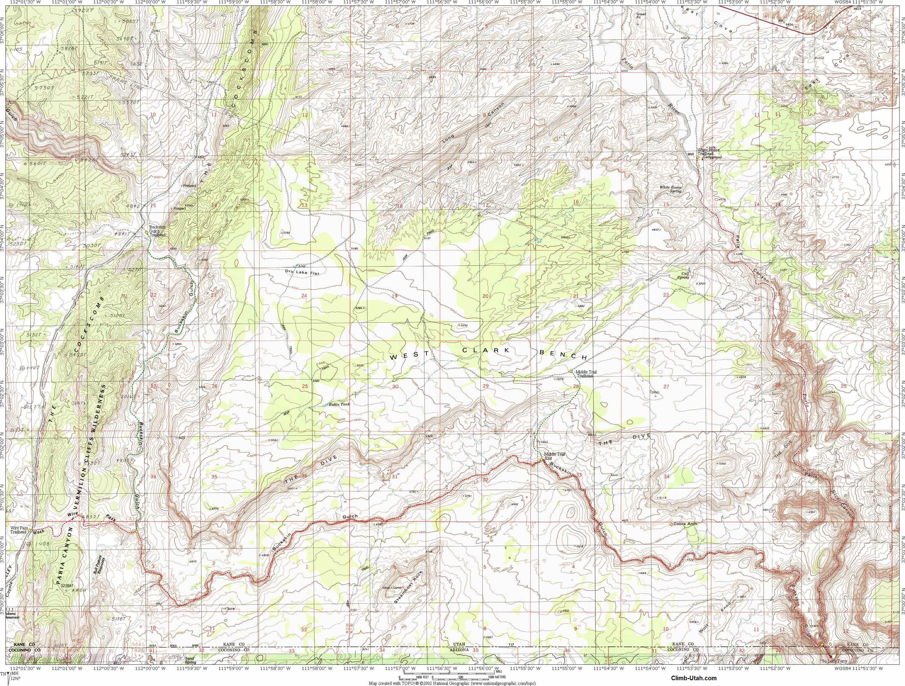
Permit: Permits for day hiking in Paria Canyon and Buckskin Gulch can be obtained at the self-pay stations at each trailhead. There is no limit on day use. For overnight trips into Paria Canyon and Buckskin Gulch, you must apply for and purchase a permit in advance. Overnight entry into the canyons is limited to 20 people per day. This is a cumulative total from all trailheads. This system helps to reduce the potential impact to the environment and allows visitors to enjoy a true wilderness experience. Overnight permits can be applied for and purchased on-line from the Arizona Bureau of Land Management. To obtain permits by phone call 435-644-1200. Trailhead Information:From Kanab, Utah drive east on Highway 89 for 44 miles to mile marker 20.9 and the signed Paria Canyon turn-off on the south (right) side of the road. Drive 2.2 miles down the well-maintained dirt road to the signed White House Campground. The trailhead has vault toilets and primitive camping. This is where your hike will end and where you should leave your shuttle car. Look around at the cliffs so you will recognize them as you finish your hike up the Paria River. Return to Highway 89. From where the dirt road joins highway 89 drive back towards Kanab for 4.9 miles. As the road approaches the top of the ridge look for a well-maintained dirt road on the south side. Drive south down the dirt road 8.5 miles to the Wire Pass Trailhead. This trailhead is signed, has a vault toilet and a large parking area. Shuttle Information:
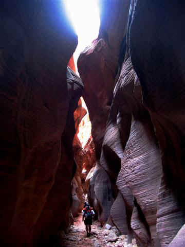
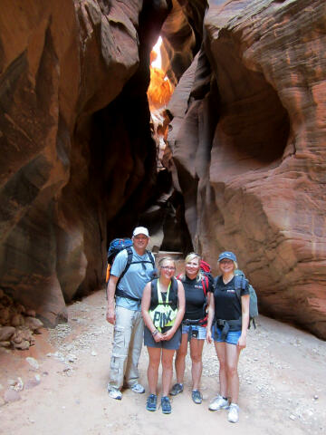
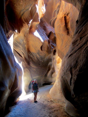
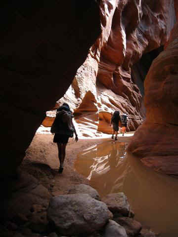
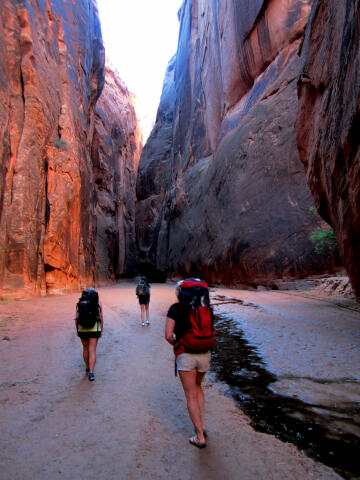
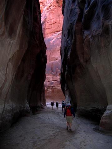
From the Wire Pass Trailhead (N37° 01' 12", W112° 01' 25") the signed trail proceeds east for a short distance along the south side of Wire Pass wash, then drops into the sandy bottom of the wash and descends eastward. At first the wash does not seem like the start of the world's best slot canyon, but within a mile things begin to change drastically. The sandstone walls begin to rise and your adventure is underway. There are two obstacles in Wire Pass which require some minor scrambling to climb over. Both are easily defeated with a small assist from your partner. Wire Pass joins Buckskin Gulch after 1 3/4 miles. There are several petroglyph panels at the junction of the two canyons (N37° 01' 11", W112° 00' 10"). The petroglyphs are located on the south (right) wall of Wire Pass just before the junction. Check the sky one last time because there is no exit from Buckskin Gulch until you reach the Middle Trail 6 1/2 miles down canyon. Hike down the flat bottom of Buckskin Gulch. The next several miles are easy hiking with several pools of standing water to impede your way. The pools are usually less than waist deep and are often stagnant. Depending on the time of year, the pools can be very frigid. If it has rained recently there will be a layer of slippery clay mud covering the sand. 6 3/4 miles after leaving the Wire Pass petroglyphs you will notice the canyon rim starting to get much lower. This is an indication you are about to reach Middle Trail (N37° 01' 53", W111° 55' 19"). Middle Trail is not a trail, but rather a route you can scramble up to the top of the north rim. The route is occasionally cairned, and if not it is still moderately easy to locate. Examination reveals a narrow crack running horizontally up the face of the cliff. It is located in a short, open section of the canyon where the walls are not steep and the rim is only 100-feet above the canyon floor. This is an emergency exit if the weather is deteriorating. Experienced hikers will have no problem with this exit, all others will require a rope. There are several very good panels of petroglyphs where Middle Trail joins Buckskin Gulch. If you stand in Buckskin Gulch and look at the Middle Trail Exit a nice petroglyph panel is located on the right side of Middle Trail Exit approximately 20-feet up. The panel is excellent and consists of two big horn sheep. 50-feet down Buckskin Gulch on the north wall there is a large number of very faded petroglyphs. 100-feet above the faded petroglyphs, located in a horizontal black streak of desert varnish, is one of the best petroglyph panels you will ever see. I have no clue how this panel was chipped since I can find no way to reach it without technical gear. You must hike down Buckskin 100-feet and look back toward middle trail, or climb up the ledge system opposite Middle Trail Exit to see this panel. After leaving Middle Trail the canyon is somewhat open for a ways, before the walls close in and the slot becomes very deep and dark. There is usually no deep wading below Middle Trail, but you might encounter some knee-deep pools. 3 miles below Middle Trail you will encounter the infamous rock jam. This is a pile of huge rocks that have become wedged in a tight canyon constriction. This rock jam is Buckskin Gulch's most serious obstacle. Sometimes there is a very easy route that allows you to crawl under the rock jam. This opening is often referred to as the rabbit hole. Sometimes the opening is clogged with debris and sand. If the rabbit hole is open you are in luck, if not, your only option is to climb over the top of the rock jam. To do this most people will need a 40-foot rope to use as a handline and to lower packs. Rock climbers, technical canyoneers and experienced hikers should have no difficulty with this obstacle. 45 minutes below the rock jam you will pass by a series of seeps in the Navajo Sandstone walls that supply a tiny flowing stream on the canyon floor. The seeps are a good place to obtain fresh water. 1 1/4 miles below the rock jam and 1/4 mile above the Paria River confluence (N37° 00' 05", W111° 51' 57"), you will come to the two best campsites in the canyon, one located on each side of the canyon. The sites are easy to spot with a large grove of maple and box elder trees growing in the sand above the streambed. There are many good places to make camp under the trees on the benches of dry sand above the canyon floor. You might have to share this area with others since camping space is very limited. The next closest campsite is located about a mile away in Paria Canyon below the confluence. At the Paria River confluence, you turn north (left) and hike upstream in Paria Canyon. The place where the two canyons come together is extremely spectacular. The narrows here are more open than the narrows of Buckskin, with smooth, shear, red sandstone walls. The presence of clean running water at the bottom of the 800-foot gorge adds a touch of grandeur to the scene. The Paria is often dry, but there is always at least a trickle of water flowing out of Buckskin. If the Paria is flowing low to moderate consider yourself lucky since it makes the hike out much more enjoyable. After hiking up Paria Canyon for 1 mile you will come to Slide Arch. Beyond Slide Arch the canyon walls become less shear and the canyon widens until it is just a desert wash. From Slide Arch it's 6 1/2 miles up river to the White House Trailhead (N37° 04' 45", W111° 53' 26").
Optional
Route Information: If you have an entire day to spend the hike from Wire Pass Trailhead down to Middle Trail and back should leave you exhausted. The Hike from White House Trailhead down to the confluence of Buckskin Gulch-Paria Canyon and back is a popular day hike. However, this has never been a day hike I consider exceptional unless water is flowing in the Paria River. The reason is the top half of the hike is not really very interesting, mostly a sandy slog down an open wash. I would consider the Wire Pass option a much better use of your time. For the Hardcore backpacker you can always begin at White House or Wire Pass Trailhead and hike the entire Paria Canyon down to Lees Ferry. This will take from 3 to 5 days. For what it's worth, I consider hiking Paria Canyon and skipping Buckskin Gulch to be criminal. Buckskin Gulch is without doubt the meat of the sandwich.
Rattlesnakes: Video: Related Link: [ Homepage ] [ Introduction ] [ Warning ] [ Ratings ] [ Ethics ] [ Feedback ] [ Updates ] © Copyright 2000-, Shane Burrows |