[ Homepage
] [ Introduction ] [ Warning ] [ Ratings
] [ Ethics ] [ Feedback ] [ Updates
]
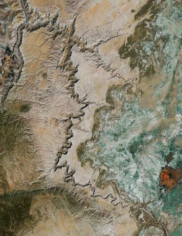 |
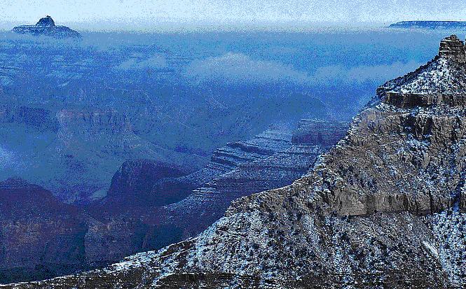
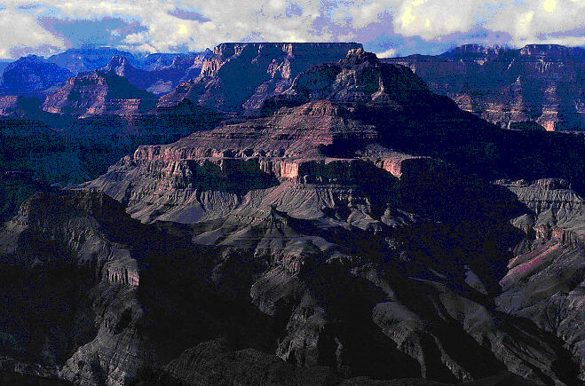
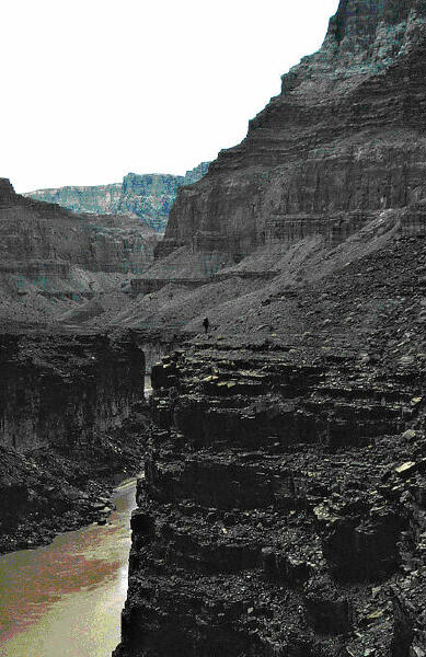
Little Colorado River
Gorge
January 1980
Rex Welshon
In
January, 1980, Charlie L, Gary W, Ron W, Frank V, John B, and I hiked
from Cameron, Arizona, to Grand Canyon National Park by descending the
Little Colorado River Gorge, traversing the Beamer Trail, and ascending
the Tanner Trail to Lipan Point. The trip took us fifteen days from
start to finish, four more than we expected. Along the way, we crossed
the Little Colorado almost a hundred times and encountered deep
quicksand. Gary partially tore his ACL on the fifth day and completed
the trip using a jerry-rigged splint and crutch. During the last three
days we were in the Little Colorado River Gorge itself, the river
flooded and stayed above flood stage almost until we got to the Beamer
cabin at the confluence with the Colorado.
It's been a long time
since this adventure, and the six of us are now a long way from being
who we were then. Nevertheless, many of my memories from this trip
remain utterly vivid. No individual part was as frightening as, say, a
long free rappel off a single bolt, and no single day was as
individually memorable as a couple of others I've spent in the boonies.
But the way the various aspects and components added up together have
made this trip indelible. A while back, I had the idea of gathering my
remaining thoughts about it. It's taken a while.
|
Day 1:
Arriving at Grand Canyon National Park at around 10 am, we
inform the ranger at the permit desk what we plan on doing. He looks at us
stony-faced. "I'm not telling you that you can't do it, but I am telling you
that you shouldn't. I won't give you a permit for any part of it. You'll be
on your own in the Little Colorado - we won't rescue you in there. But if
you make it out, tell us." To be honest, that's the kind of response we're
hoping for. We're in our mid-twenties and think of ourselves as experienced
mountaineers and desert rats. Do we think about floods? Uh, no. Do we think
about quicksand? Sorry. Do we think about injuries? No more than usual. We
know nothing other than that the gorge is about fifty miles long and looks
wild. None of us has ever heard of Harvey Butchart; Michael Kelsey's warning
that the Little Colorado is a "quicksand deathtrap" from Hiking Guide to the
Colorado Plateau is still five years from being published.
The ranger gives us
permission to park a car at Grandview Point, so for the next three hours we
ferry people and our other car to a side canyon, about two miles west of
Cameron, that we're using to enter the Little Colorado canyon. As we're
driving to the put-in point, we pass a hogon. "Shouldn't we ask permission
to leave our car?" I remember someone asking. The consensus answer is "no" -
the hogon appears deserted and our parked car can't be seen from it even if
someone does happen by. We're ignorant - we don't know a thing about Navajo
permits, whether they're required, or, if they are, how to go about getting
one.
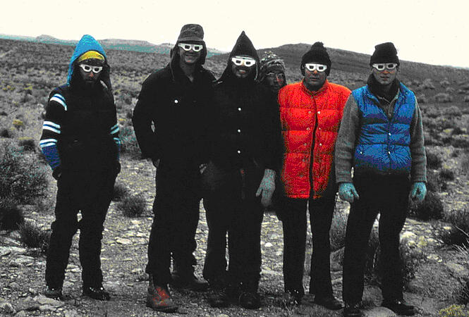
Everything gets packed up and we take a group photo: six long hairs wearing
Neil Young "Rust Never Sleeps" 3-D glasses from the Denver concert the
previous year. Quickly dropping through the side canyon to its junction with
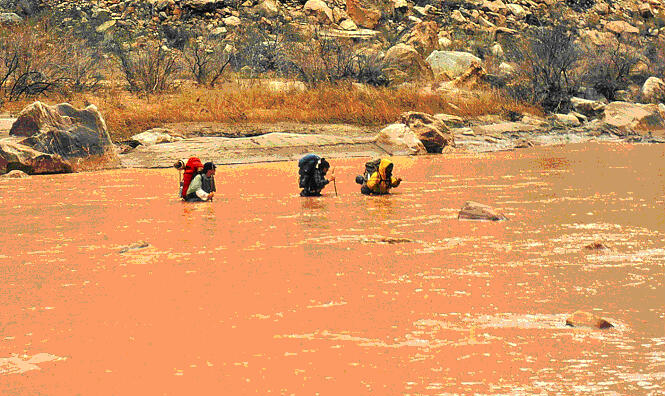
the Little Colorado, we note three things: our packs are heavy, between
seventy and ninety pounds apiece; the river is flowing at a pretty good clip
- maybe 200 cubic feet per second; and there are ice chunks floating in the
brown water. The heavy river flow and ice are both unexpected. The Little
Colorado should be dry in winter; that's why we've chosen to do the trip
now. We palaver and decide to keep going - we can always retreat if we have
to.
We're off then, at three o'clock
in the afternoon, and will top out Grandview Point in eleven days. It starts
to rain lightly and, after fifteen minutes, the canyon cliffs out on our
side. A crossing is in order. Being experienced, we have come prepared. We
have special shoes for the occasion: blown out running shoes, tennis shoes,
and Converse All-Stars (it's 1980 - our hiking and mountaineering boots,
which we're wearing, are made entirely of leather and there's no such thing
as a canyoneering shoe). It appears however that some of us are not quite as
prepared as we might be. John doesn't have any rain pants or shorts and
while I have a swimming suit, all I have for lower leg coverage are rain
chaps. Chaps work fine if you're wearing a long rain parka and long pants,
but of course we're taking our army surplus wool pants off and wrapping them
up tightly inside Glad trash bags to stay dry. I probably should have
thought about that a little more. Oh well - there's John, in wool shirt,
white briefs, and All-Stars; here's me, in wool shirt, swimming suit, chaps
tied to shirt tails and drooping almost to my knees, and an old pair of
Adidas. We look like someone's weird fantasy gone wrong.
When Charlie throws his
boots across, one of them dutifully lands in the water and starts floating
down river. He's off like a shot, chasing it as fast as he can on dry land
before wading in and shrieking when he instantaneously sinks in to his
crotch. The rest of us cross at a shallower spot. The water is cold but
we're across quickly. On reaching the other side, we dry off our feet, put
our boots back on, and head off. Two hundred yards later and around the next
bend, the boots are off again for another crossing; three hundred yards
later, another bend, another crossing; a hundred and fifty yards after that,
another bend, another crossing. Hmmm, there appears to be a pattern here -
when the river runs up against something it can't get through, it goes a
different way, and that means we have to cross. Okay - this
taking-the-boots-off-putting-the-running-shoes-on-taking-the-running-shoes-off-putting-the-boots-on
thing is a waste of time. We're just staying in our shoes. For those of us
whose shoes hold together, boots won't come out of the packs again for a
week.
At dusk we emerge from a shallowish walled stretch and look ahead. The river
is braided and spread out about twenty feet wide and a foot deep. We walk
next to it and encounter our first quicksand. Actually, I step right into
it. It is next to the main body of the river at a place where the water is
flowing lazily, about an inch deep. All of the sand ahead looks the same,
but one footstep is solid, the next three are kind of mushy, and on the
fifth I sink into my knees. The others come over and laugh at me. After
squirming around and realizing I'm not going in much farther, they pull me
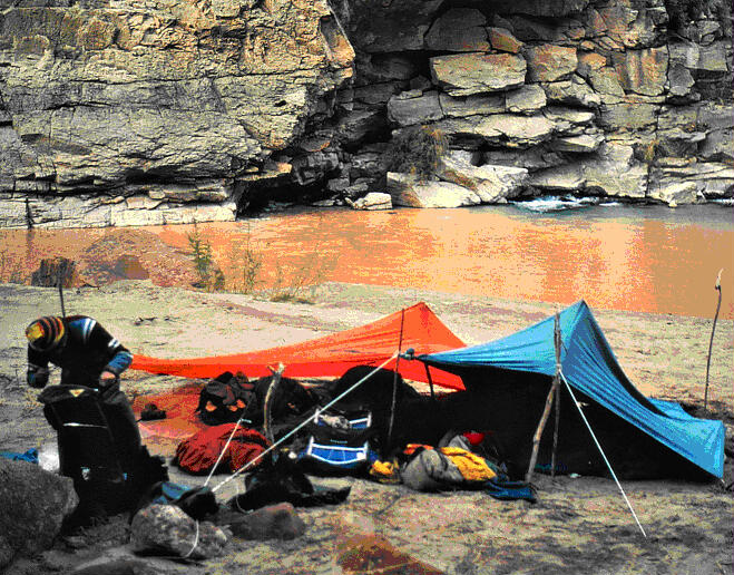
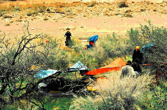
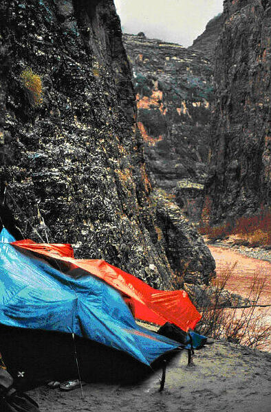
out. We're losing light and decide to camp. A patch of sand in the tamarisk
is ideal, so we think about but reject putting up tarps (we didn't bring
tents - we're in the desert for goodness sake and it's dry in the desert),
and cook dinner over a tamarisk fire. While it's cold, there is no wind and
everyone stays dry.
Total miles day 1:
4
Day 2:
Rain is spitting lightly
but stops soon after we start hiking. After three hours, we round a
southeast to northwest corner and get a clear view of the next mile or so of
canyon. Where we're standing, the canyon is about one hundred feet deep and
maybe three hundred feet wide at the top. At the next curve a mile further
and a benched layer deeper, it's more like six hundred feet deep and a lot
narrower. We can't see the bottom. Debate ensues: stay on the bench or
follow the river course? Ron's all for the river because he's worried about
getting cliffed out on the bench and having to climb down through rotten
sandstone or limestone. We have a fifty foot rope, biners, and some webbing,
but nothing more. After scouting out the high road option and discovering
that there is no way into this canyon within a canyon from the side, Ron and
I return to inform everyone that we're going to have to get in the river.
 While the Little Colorado and Colorado rivers have cut spectacular gorges,
the Little Colorado River Gorge drops only 1700 feet in its entire fifty
mile run from Cameron to the confluence with the Colorado. At the same time,
the canyon incises a canyon that at Cameron is less than a hundred feet deep
and becomes at the confluence 3800 feet deep. The difference between the
height of the canyon walls at the confluence and the river's drop over its
run through the Gorge is 1800 feet, equal to the amount of uplift between
Cameron, at 4200 feet, and Cape Solitude, right above the confluence, at
6000 feet. The result is that, despite getting ever deeper as it cuts
through strata of sandstone, the Little Colorado doesn't drop over twenty
feet at a time anywhere in the Gorge and, until Blue Springs, doesn't even
have many rapids. Its lazy demeanor through the first half of the Gorge
allows it to carry and drop tons of sediment, which makes for completely
undrinkable water but good and plentiful quicksand and mud.
While the Little Colorado and Colorado rivers have cut spectacular gorges,
the Little Colorado River Gorge drops only 1700 feet in its entire fifty
mile run from Cameron to the confluence with the Colorado. At the same time,
the canyon incises a canyon that at Cameron is less than a hundred feet deep
and becomes at the confluence 3800 feet deep. The difference between the
height of the canyon walls at the confluence and the river's drop over its
run through the Gorge is 1800 feet, equal to the amount of uplift between
Cameron, at 4200 feet, and Cape Solitude, right above the confluence, at
6000 feet. The result is that, despite getting ever deeper as it cuts
through strata of sandstone, the Little Colorado doesn't drop over twenty
feet at a time anywhere in the Gorge and, until Blue Springs, doesn't even
have many rapids. Its lazy demeanor through the first half of the Gorge
allows it to carry and drop tons of sediment, which makes for completely
undrinkable water but good and plentiful quicksand and mud.
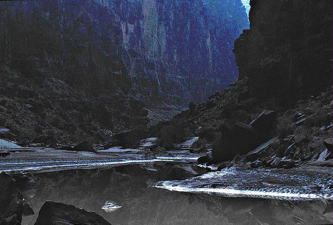
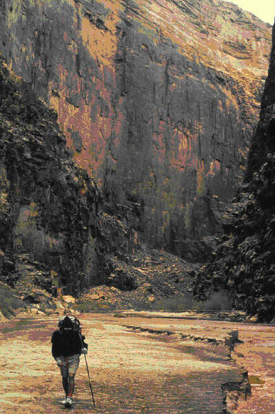
In the canyon within the
canyon it's only fifteen feet wide, dark, and cold, really cold. We're in
the water most of the time for the next mile, usually up to our knees and
sometimes higher. It's cloudy and the air temperature is about 40 degrees
Fahrenheit. Luckily, the exertion keeps us from shivering too much. At some
holes we go in up to our waist, and we find plenty of quicksand, always in
the same kind of setting, next to the river where the water is barely
flowing. This section may be what Kelsey calls "Quicksand Alley." Frank goes
in and works his way up to his navel, laughing like a hyena the whole time.
It takes a considerable group effort to get his idiot ass out of the muck.
About an hour later, while Ron and I are in the lead and out of hearing
distance, Gary sinks up to his neck and is prevented from disappearing
altogether only because Charlie, who is walking next to him, snatches the
bar at the top of his frame pack and keeps his head above the sand long
enough for John to come over and yank him out. That sends a strong and
unambiguous message. Someone comes up with the bright idea to use probes on
the river crossings and to walk single file behind the leader. We
immediately implement the practice and keep to it until we no longer have to
walk in or immediately next to the river.
For the rest of the day,
the Little Colorado continues its cut through Coconino sandstone. I don't
remember any large drop-offs requiring rappels in this section, but I do
remember a longish section of sloping slick rock bench with the river
flowing right over the top of it (I've seen that other places, so maybe I'm
misremembering it). This part of the canyon is continuously extraordinary.
The walls get taller and taller, dead vertical to slightly overhanging,
narrowing the canyon both at the bottom and the top.
John's been complaining about being cold for most of the day; by three
o'clock he's slowing down, stumbling, shivering violently, and slurring his
speech. Experienced mountaineers that we are, even we recognize hypothermia
at the point when the victim becomes incompetent. It must be time to stop.
We're near our planned camp for the night anyway, at a southeast to
northwest turn in the canyon close to a gauging station, so we set up on
sand on the north side of the river under a large alcove where there's no
need for tarps. Across the river - thirty feet or so - the wall rises
directly in an uninterrupted sweep of outwardly veering sandstone for at
least eight hundred feet, stained with six hundred foot long ribbons of
desert varnish. Getting John into his sleeping bag takes about five minutes
and, over the next couple of hours, he regains his core temperature. The
rest of us hang out, talking. By the time he recovers, the light is gone.
Total miles day 2: 8
Days 3-7:
The next five days have
more or less merged in memory into one long, ever-deepening, ever-expanding,
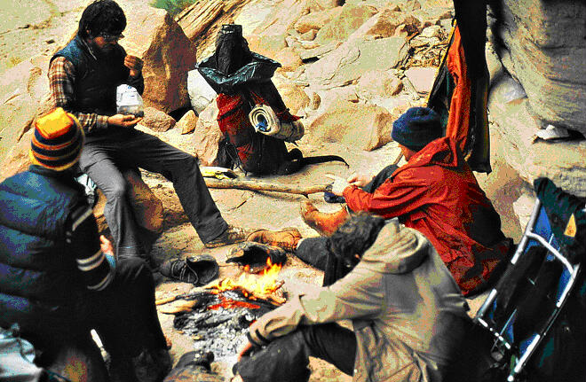
day. I typically rise first and blow the embers from the previous night's
fire back up into a cooking fire for breakfast. We eat, have something hot
to drink, scatter ashes, and start another day of walking next to the river,
still flowing strong but now ice-free. The weather improves to tolerable
hiking conditions - mostly cloudy and about fifty with cool nights in the
twenties. After our quicksand encounters during the last two days, we've all
found stout sticks to use as probes. Wherever we're a little doubtful, we
proceed with the sticks in front, prodding and poking the unseen river
bottom. There's plenty of the stuff, but with a couple of exceptions we
avoid getting trapped, and even those exceptions aren't as scary as what
Gary experienced.
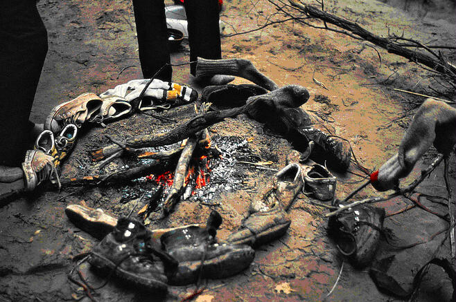
On the other hand, the mud is quite irksome, much more so than quicksand.
Our shoes and lower legs are completely coated in muck. Every time we cross
the river some of it rinses off, but because there's so much of it where we
need to be walking, we inevitably post hole through more, and post holing
through mud isn't like post holing through snow - it's sticky, slippery, and
grabs our legs in a vice grip. Clearly, a major flood has occurred within
the last month and has brought huge amounts of detritus and silt-laden water
down the canyon. We're walking through that flood's drying remains and, as a
result, the going is considerably slower than expected. We can't walk
downstream in the river itself because the water is often too deep and even
where knee-deep or less, it is so completely opaque that we can't see where
we're putting our next foot. Our fear of taking one wrong step and getting
sucked under by mud or quicksand is so fully engaged that we do whatever we
can to stay out of the river and go way above the merely cautious when we
cross.
Since the river itself is
not navigable, whoever is on point has to figure out how we're going to get
downcanyon. For various reasons, most of them having to do with the fact
that we're the tallest, Ron and I do a lot of the leading. It's hard work.
After half a day of leading, we usually have a headache from making so many
decisions. At any point, we have to determine in 50-or-so-yard-segments
whether to cross the river, and where (after several false starts) to do it,
whether to go for the slightly less dense than usual thicket of tamarisk
(and whether or not this will leave us at a river pool), whether to traverse
the base of a cliff and risk it cliffing out, whether to go for the locust
jungles, whether to pass between these two house-sized boulders or those
two, whether to let the rest of the group catch up or not (it's best when
the leader is slightly ahead of the other five so to have time to make
several short backtracks when routes didn't go, so the group doesn't have to
wait).
In two ways the recent flood is a boon - there's lots of driftwood for fires
lying about and, so long as we keep our eyes open for it, we never have to
worry too much about having water even if what we get is awful. We all ran
out of whatever water we had brought with us after the first day in the
canyon, but there are enough streamside eddies full of slowly de-silting
water that we can replenish water bottles at least once a day. The problem
is that the water is nasty. True, it's been settling for a couple of weeks,
but it's gritty, terrible tasting, and a long way from being clean. I don't
remember whether pumps were available then; I know none of us had one. So,
into every bottle we're dissolving iodine tablets that provide a safeguard
but do nothing to improve taste. Our Wyler's drink mixes are lifesavers, but
even they can't cut the grit or the underlying queasiness we feel about
putting this solution in our stomachs. We don't drink a whole lot and are
constantly on alert looking for good water. There isn't much.
Midway through this five day stretch, right below Hell Hole Bend, Gary slips
while jumping from a mud-covered rock and badly torques his knee. We don't
consider going back for long. He reassures us that he will be fine in a
couple of days, so we put together a splint of driftwood and webbing and
continue down-river. My memory suggests that we managed around five miles a
day through this stretch, camping below Hell Hole Bend on the fifth night,
just west of Point 5454 after the river starts running north on the sixth
night, and at Waterholes Canyon on the seventh night, after chasing a family
of deer down canyon during the afternoon.
Each one of the days in
this stretch has some misadventure. At the end of what must have been the
sixth day, we come to a particularly bad river crossing where the river runs
wall to wall for at least thirty yards. We have to cross twice in that
thirty yards, but the river is sluggish, muddy and deep. Ron tries crossing
several places and at each the water rises immediately to his thighs. It's
getting dark. Gary, in a full rain suit, a limp, and a full pack, wades out,
trying to get to a rock near the far shore. He sinks in up to his thighs as
well. We have just started to understand that boulders in the water have
deep holes carved around them by water action. So he jumps for the rock.
Luckily, he reaches it, but he is now stranded, straddling a rock with
over-the-head water surrounding him on all sides. We decide to camp where we
are and rescue him. Ron, Charlie, John, and I gather wood for the fire Gary
will soon need. Frank pulls out some webbing, manages to rescue Gary's pack
without it getting wet, and then tries to help Gary off the rock. As we're
standing next to the fire about twenty yards away, we hear a large splash
from the river and wonder whether one or two have gone in. Gary comes
sloshing up, his hair dripping. He is followed by Frank and his pack, which
is dry as a bone. We all break up laughing.
The seventh day starts
badly, for we have to complete the crossing. Ron scouts it out and discovers
a complicated way along the thirty yards of cliffs on our side. Taking his
pack off, he wades in and again sinks in the mud. Rather than go in any
further, he chimneys up behind a fifty foot tall boulder. Once on top, he
climbs back down a few feet to a bench and lowers webbing to haul the packs
up. Without packs, the rest of us wade over and climb up the chimney. We put
our packs back on and begin a sixty foot ledge crossing. The middle twenty
feet are narrow, completely exposed to the river almost a hundred feet
below, and covered with a ceiling, providing about three feet of clearance.
We have to crawl on our knees, the rock gently nudging us and our packs
outwards toward the edge. All in all, it takes about an hour and a half to
traverse 90 feet of canyon, but it saves two submarine crossings. It's also
apparent to everyone that we we'd be lucky to get back across that traverse
without an accident.
Towards dusk, we have to
cross the river for the umpteenth time. Frank tries a dangerous crossing,
slips, and falls into the river. After getting back up, he gets cliffed out
by a huge boulder at the far side and has to be rescued. Meanwhile, the rest
of us wade at a bad spot and John steps into some quicksand, falls forward
into the water, pulls himself out, swearing up a storm and pouring a quart
of water out of his boots, which had been on the outside of his pack. That's
it - we're done for the day and again make camp in a sorry spot with an
excellent beach in view across the river. We've discovered that we're not as
far as we thought (this is back in the day of 15 minute quads, which don't
show a lot of detail - besides, except for Hell Hole Bend, one bend on the
map looks pretty much like another). What with the mud-induced pace and the
various challenges we've run into, we're at least two days behind where we
should be. If we keep eating the way we've been eating, we'll run out of
food before we get out, so we decide to scrimp a little each day. Overnight
it rains. We stay almost dry under the tarps, but most of what we are
wearing is sodden and will remain that way for a week.
Total miles days 3-7: maybe 25
Day 8:
We expect finally to
reach Blue Spring this afternoon after a seven mile hike. After three
pleasant days in the fifties, the air temperature has dropped back into the
lower forties, with leaden skies and a strong breeze. As it turns out,
today's walking is just more of the same old, same old - lots of mud, a
dozen or more sketchy river crossings, and constant vigilance for potholes
and side canyons so we don't have to drink what we're carrying. There's
almost none of the first, absolutely none of the latter. So, we've been
looking forward to camping at Blue Spring because the name sounds appealing
and because we're expecting it to provide high quality drinkables.
The canyon becomes
unusually tight and a little chaotic - boulders and rocks litter the river
bed and negotiating them takes time. Late in the afternoon, we reach a
spring, immediately identify as the Blue Spring, and declare the day's
hiking over. It is quite interesting visually. The aquamarine water emerges
at the top of the Redwall Formation, pumping about 50 cubic feet per second
from springlets in and near the river bed and a couple of much larger
springs immediately next to it. The flow introduced from the springs
transforms the Little Colorado from an intermittently running stream into a
permanently flowing river and adds the minerals that make the travertine
dams for which the lower stretches of the Gorge are well-known. Since the
river is flowing heavily already above the springs, it's brown again five
feet below them. But the water itself is god awful -oily to the tongue and
alkaline to the taste buds. For reasons that remain unclear to me even now,
we call it 'sweetwater.' We cook with it for three days and drink it with
lots of Wylers lemonade powder added to it. Even then it gives some of us
the runs.
That evening Ron and I cross the river to get a closer look at the spring we
can see from our campsite. We wade out without pants and are soon in up to
our waists, so we take shirts off and try again. Up to our navels this time,
but we make it. The spring gushes from some cracks in the limestone and
forms three or four bathtub size pools, then flows away. The water is
slightly warm and we sit in it. Hey, that feels good - anything is warmer
than what we've been used to for the last five days. While I return to camp,
Ron scouts downstream, finds another large spring, and then comes upon the
really big one - a series of three ten-foot deep pools, clear and
aquamarine, and flowing slowly but with great volume, probably 200-300 cubic
feet per second. He wades in front of them, walks some more beach, notices
another crossing that will have to be done in the morning, and returns in
the gathering darkness. It rains again overnight.
Total miles Day 8: 7
Day 9:
This is the first of
three hard days: by dusk, we will have managed all of three miles. We start
off in rain pants and wool sweaters, and regularly wade up to our navels.
Half-way through the day, we are forced by cliffs on both sides to cross at
a bad rapid. I lead into waist deep water and a strong current, trailing two
long pieces of webbing. I find a rock midway in the river and set myself up
as an anchor. Ron holds the other ends of the webbing and sends the others
across to me one at a time, each holding the webbing as a hand line. Charlie
slips into a deep hole, goes up to his neck, and then jumps for the rock.
Ron is last and has only the end of the line in front of him. He too jumps,
slips, and gets soaked. Once we are all huddled around and holding onto the
rock, I lead the easier second half of the rapid and everyone else follows.
We build a lunch fire and try to dry our sweaters. The afternoon produces
more deep but "easy" wades, with one exception. Ron feels out a crossing and
steps off a sandbar into a mud hole. He has to take a couple of breast
strokes back to shore before trying somewhere else. We can't wait for sleep
to end what has been a miserable day.
Total miles Day 9: 3
Day 10:
We hope to make it to the
Sipapu, where the Ancient Ones emerged into this world. It's about eleven
miles away. With an early start, we'll be there just as it's getting dark.
Well, it's a good idea, but it is not to be. By early afternoon, we're at a
point where the river makes an 'S' turn, from going almost due north, to
going southeast, to going almost due north again in a straight shot to Big
Canyon. We encounter the most serious rapid we've seen so far - it's
actually kind of big, Class III, maybe Class IV, and it continues for a
hundred and fifty yards all the way around the north to southeast portion of
the 'S'. Of course, we have to cross it. An enormous gust of wind roars down
canyon over us. It dies down for two minutes and then another gust comes
down canyon. This time the wind doesn't fade - it blows a steady twenty-five
miles an hour with gusts to fifty. Charlie and Gary are looking for a place
to cross the rapid at its rockiest place, near the top; Ron, John, Frank,
and I have chosen to cross it at its narrowest point about fifty yards
downstream from them. The river slams into a cliff thirty yards below us.
Ron has a good idea: set
up the rope across the river, then, using it as a zipline for the packs and
a handline for the people, get across. It is twenty feet to the other side,
with maybe eight feet of serious current to worry about. I offer to go first
and tie the rope around my waist. I get to the edge and, holding onto a rock
to brace myself against the current, test for the bottom. Nothing. I test a
little deeper - ok, it's there and I'm in past my navel. I put my foot out
for another test plant, and step into nothing but deep, fast water. WHOOOP!
- I'm completely submerged before I know it and then my pack pops me back up
like a cork. Shit - I'm heading downstream with a rope tied around my waist.
This is not good. Luckily, Ron has the good sense not to reel me in (pulling
against the current would drag me right into and under the fastest and
deepest section of water). I thrash and yell and splutter and blubber and
kick my way to the opposite bank and emerge about twenty feet downriver,
soaked to the bone.
I return to our crossing
point. We use meat belays on both sides to tighten the rope six feet above
water level and on a slope to me. John's pack comes across hanging from a
biner, dragging through the water for the last six feet. This job takes just
enough time for me to start to chill down. When John comes across, he's
white with fear and I'm chattering away doing a full body shiver dance. He
is swept off his feet twice and barely makes it. Then it's Ron's turn: the
current lifts his feet and he too does a face plant into water. Finally, the
three of us just haul Frank across, but I'm shaking so hard I can't do much
of anything. Someone yells at me over the rapid's roar to get out of my wet
stuff and into some dry clothes. Ron and Frank go looking for Gary and
Charlie upriver while John and I shoulder packs and head for higher ground.
The others' packs and the rope stay propped up against the bank where I put
them.
Between the river's edge
and the sand bar that I'm headed for is a fifty foot wide swath of broken
ground that would be inundated were the river to flood. I strip off my
swimming suit, T-shirt, rain jacket and chaps and try to get into my dry
wool shirt, dry wool pants, and dry wool socks. But I can't button my shirt
or zip my pants, and every time I try to put on a sock I fall over. Fuck it
- I put my down booties on over bare feet and slip a down jacket over the
unbuttoned shirt. That's better. Still shaking violently, I climb up the
eight foot sand bar. It's perfectly flat on top and sparsely covered with
grass. There's some wood lying around, a few smallish junipers, and a couple
of other larger bushes of some unknown species. The air temperature is
dropping and it's spitting rain sideways. I'm still shaking, but it's
getting less violent and as long as I keep gathering wood it will end. Gary
and Charlie show up, wet to the neck. One of them starts a fire with stove
gas. The other three arrive shortly after, all of them soaked and shaking.
Frank, Charlie, and Ron return to the river to retrieve the packs and the
rope, while John, Gary, and I huddle around the fire and lay out shoes and
clothes to dry.
When the others return with the packs, Ron mentions that some of the rope
was in the water when he found it. I guess I must have left it like that;
good thing it didn't float away. We take stock of our situation and debate
whether to continue. It's probably three o'clock. The wind has subsided a
little and it's begun to rain, not hard but steadily. The spit we're on is
thirty feet long, ten feet wide, and attached to the southern wall of the
canyon like a portaledge. From the back of the spit, where we are, we can
see downstream a little ways but not upstream at all. The edge of the spit
drops eight feet to the floodplain, which narrows from the area of the creek
crossing and pinches off completely near our peninsula's downstream limit.
Further down, about a quarter mile away, the river completes its 'S' by
turning northward and passing through a rock gate that is perhaps seventy
feet across, with three hundred foot walls rising directly from the water on
either side. Above that, the remaining terraces, walls, and benches ascend
unseen 2500 feet to the top of the canyon.
Since the river turns as
it passes through the gate, we can't see any further downstream, so we pull
out the topo map, which suggests that it runs in a straight corridor for the
next three or four miles to Big Canyon. If the corridor continues to Big
Canyon the way it starts - seventy feet wide with three hundred foot walls
on each side - then, given what we've encountered in the last two days, if
the river floods big we could easily get trapped. However, and again given
what we've encountered in the last two days, if the river floods big and we
can't get through the corridor, we'll be trapped where we are now, with no
escape upstream or downstream. All things considered, we're in a tight spot.
Charlie volunteers to
sneak a peek downstream. He's back in less than two minutes - he reports
that the river is already out of its banks, onto the floodplain, and rising
fast. Well, that makes the decision for us: we'll stay put at least for the
night. So long as the river doesn't rise more than ten feet, that is, so
long as the flood isn't biblical, we'll be okay on our little sand spit for
a couple of days before we're out of food. We set about collecting all the
available firewood and putting up the tarps before it gets dark. We have
barely enough water to boil dinner and none at all for breakfast. I couldn't
care less. I feel like my wool sock hanging over the fire - shapeless,
floppy, and impregnated with sand, mud, and water. The drizzle continues
through dinner, comes and goes for about two hours afterwards, and then,
after we're in our sleeping bags, changes to a hard, continuous rain that
lasts all night. Squeezed under the tarps in all of our available wool
clothing, we're as smelly as wet sheep. Living the dream, for sure.
Miles day 10: 4
Day 11:
When we awake, it is of
course still raining. No one has slept well and everyone is wet from various
tarp leaks we were too tired to deal with overnight. Charlie and Ron are
wetter than the rest of us. Not that it really matters - we're all about to
get drenched. I walk out to the upstream end of the spit and look at the
river - it's spread across the floodplain, lapping the escarpment we're
marooned on. Luckily, the water is still six feet from the top where our
bivouac is located. It's an impressive and unnerving sight.
Charlie plants a stick in the floodplain to gauge the water's behavior and
returns to the tarps for breakfast. After eating, it's decision-time: do we
wait it out until the water recedes or do we go for it? We look down-canyon
- the river is running wall-to-wall through the gate and this time there's
no high route around it. Charlie returns to look at the stick in the
floodplain. It has about the same amount sticking out as half an hour ago.
Good, at least the river isn't rising quickly. That factoid becomes part of
our deliberations. After a surprisingly short discussion, we decide to give
it a whirl - if it's too dangerous we'll come back and wait the flood out.
We're low on food, but there's a runnel of rainwater coming down the wall
near camp that we can lap at until things dry out. That's all we really
need. Worse case scenario is the flood gets a lot bigger and washes us all
downstream. But that's not likely: there's no evidence that floods ever wash
this high. So, if either the current is too strong or the water is too deep
to stand up in, we're coming back; otherwise, we'll see what happens.
Charlie, John, Gary, and Frank are ready to go first and walk to the
upstream end of the spit to get into the water on the floodplain. Ron and I
follow. Okay, it's up to my stomach, maybe three and a half feet deep, with
a relentless current. I look upstream for some reason - something biggish is
being carried through the rapids. It's not a tree or a bush. It can't be
that heavy, but it's as big as - oh for Christ's sake - a cow, a dead one,
bloated, feet sticking straight out and into the air, bobbing on top of the
water like a rubber duck in the tub. Ron, who's on top of the spit
immediately above me, sees it and laughs - "maybe we should try to lasso it
and use it to float our way out of here." Not a bad idea, if you think about
it. And then its stench hits us square in the nose - all right, not such a
good idea after all.
Frank leads us toward the gate. With our probe sticks as underwater eyes and
walking in strict single file six feet apart, constantly updating each other
on conditions underfoot, we wade in. The river gets gradually deeper until
we're up to our chests and necks, being pushed insistently downstream. To
the extent that our trash bags are still dry bags, our packs are riding up
on our shoulders and provide some buoyancy: with a little practice, we kind
of bounce from step to step without being pulled up and off our feet or
being pushed over by the pack's weight. It's cold in the water, but since
we're now lower than the rapids, the river is about as level as it can get
and still flow. Thankfully, the river bottom is sand and not mud.
Frank peers around the corner and shouts back that the river is running wall
to wall for at least three hundred yards. Beyond that he can't see well
enough through the rain. It's a huge relief that there aren't any more
rapids. Then he's laughing hysterically - as always, a sure sign that
something's wrong. He's dog-paddling trying to keep his head above water.
Gary, next in line, follows suit. I'm next, but I avoid the hole they've
fallen into. I move a little to the westward cliff and, while I go in up to
my chin, I'm able to continue bouncing off the bottom. Ron and John follow
me, but Charlie ends up swimming.
I don't remember anyone ever suggesting that we return to the sand spit. It
would have been moot anyway - the current is too strong to walk against
going upstream. Had we brought along inner tubes or inflatable mattresses we
could have just loaded our packs onto them and hung on. But of course we
hadn't thought of that. Everyone is super careful; we all know that going
down the river is our only option and that doing anything stupid will
endanger everyone. And so we continue, walking, bobbing, swimming,
thrashing. My memory suggests that things went on like this for maybe half a
mile, at which point we found a place to beach ourselves briefly on the
eastern shore. But that doesn't last long and we're soon in the water again.
I do not let on to the others how worrying I think our situation is. If
anyone is swept off his feet or gets caught by something underwater, the
rest of us will be able to do nothing more than yell at him to dump his pack
before it has the chance to push him under. The image of watching one of us
disappear competes in my mind with the vigilance needed to make sure that it
isn't me.
The river continues to flood over its banks here and there and, what with
the canyon walls streaming with water, there is less walking and more
swimming at each crossing. By now, our packs and most of their contents are
getting pretty wet. While they still float, they are no longer buoyant
enough to pop us back onto the surface were we to fall into a hole. The
water at the final four crossings, each immediately above large travertine
dams, is well over our heads, probably nine or ten feet deep. We knot the
rope and webbing together and tie each guy in before he enters the water to
ensure that we can drag him out if necessary. And then, one at a time, each
of us kicks our way across, pushing our packs in front of us like floaty
toys.
All we want is to get to
the confluence without having to cross this damned river again. But there's
no way we're going to make it today - at the rate we're going, it will be
dark before we get half way. Running on anxiety and adrenaline, we stumble
and bumble our way past Big Canyon. At Salt Trail Canyon, the first good
thing to happen in three days occurs: the rain softens into a mist that
hides all but the lowest three hundred feet of the canyon. And then, quite
suddenly, something even better happens: fragments of a trail appear. My
brain re-ignites from its gloom and doom circuit. Ding-ding-ding! A trail
can come from only one direction - downriver - and it can be made by only
one kind of critter - day hikers walking upriver from the confluence. Like
magic, my dread about what's around the next corner begins to dissolve and I
find myself in a semi-dream state of overpowering relief. The world becomes
hospitable again - instead of being redundant evidence of our dire
situation, the dozens of waterfalls surrounding us now emerge miraculously
from cloud vapor above and cascade down glistening canyon walls in an
extraordinary display. And the flooding Little Colorado is no longer a
menace but a spectacular event that we're privileged to see up close. As I
wrap my brain around the thought that we're probably not going to have to
cross the river again and that we will get to the confluence after all, the
adrenaline dump begins, not just for me but for everyone. We stop under a
huge overhang, get a fire going, and watch the smoldering wood.
I don't remember much about the rest of the day except that despite the
canyon walls running with water, we have nothing to drink. Ron and I
eventually volunteer to fill bottles and find a big pothole full of clear,
clean rainwater up a side canyon. We're now four days behind and sapped, but
we're alive and more or less uninjured. Dry under the overhang and more at
ease than we've been in days, we collapse, without dinner and before dark,
into sound sleep.
Miles day 11: 5
Day 12:
The day dawns cloudy, but
brighter and noticeably warm. The river has receded overnight and is more or
less back in its banks again. We should be driving home today, but we
haven't even made it to the confluence of the Little Colorado and the
Colorado, let alone to the base of the Tanner Trail, which is fifteen miles
distant, on the other side of the Beamer Trail. Given our condition, getting
to Tanner Beach today isn't viable. We decide instead to get to Beamer's
rock house at the confluence five miles down canyon.
Within an hour of
starting down the now distinct and continuous trail, we see the Sipapu on
the other side. The sun comes out, and since the river has gone down far
enough that we can cross safely, Frank and I dump our packs, strip down, and
swim across for a look-see. It's a mound that's about fifteen feet tall and
perhaps thirty feet in diameter, chocolate-colored, and more or less flat on
the top. Scrambling up, we discover a hole in the middle of the mound, maybe
fifteen inches in diameter and without any apparent bottom, eagle feathers
stuck here and there into the interior walls.
After crossing back over,
we lounge around barefoot in the sun for some time, confident that the trail
will lead us to the confluence and the rock house. We're now low enough that
the grass is greening and trees are budding. Each of us adopts his own pace
for the rest of the day and we stroll slowly down canyon, sometimes alone,
sometimes with one of the others. The Little Colorado River Gorge is for its
last few miles overwhelmingly sublime. I still vividly recall the dramatic
enormity of the canyon - almost 4000 feet deep and multi-tiered, it induces
a paradigmatic experience of insignificance. That night we eat a little
spaghetti with bullion and sleep on long green grass under a clear sky a few
hundred feet from the confluence, a comfortable end to an unforgettable
wilderness day.
Miles Day 12: 5
Day 13:
We expect today to
traverse the Beamer Trail from the confluence to Tanner Beach in the Grand
Canyon; tomorrow we'll ascend the Tanner Trail to Lipan Point. The trail was
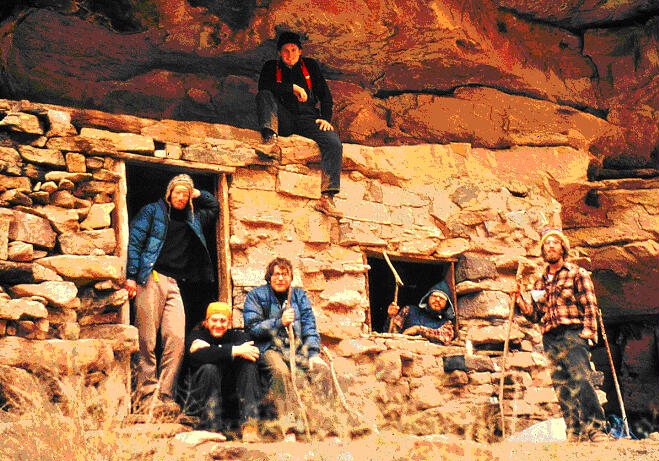
built by Ben Beamer, who tried in the 1890s to farm at the confluence.
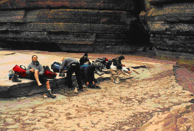
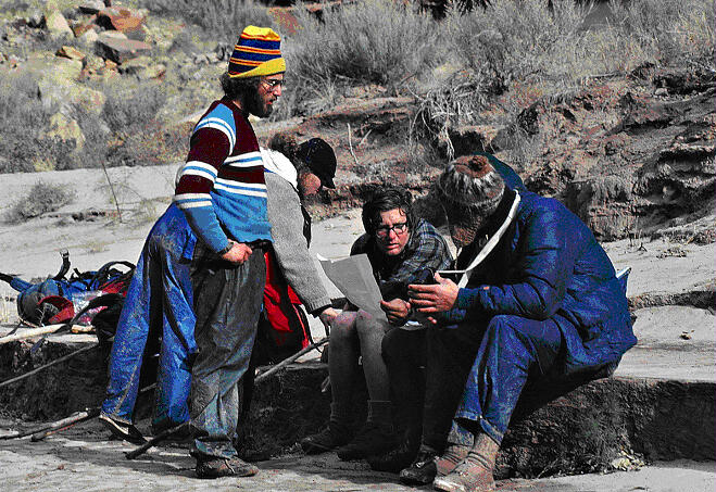
Before starting out, Ron takes a picture of us all at Mr. Beamer's rock
house: we're dirty, tired, and hungry, but smiling.
The Beamer is easy, being almost level for 5 miles as it traverses a bench
of Tapeats Sandstone immediately above cliffs that drop to the Colorado
River. At a few places the trail is indistinct or washed out, and for one
hundred yard stretch, it is so degraded that we walk across a twenty degree
slope of bare dirt and pebbles no more than three feet from the edge of a
five hundred foot drop straight to the river. It's plenty spooky. Ron,
Frank, and John cross on a higher contour where the angle and exposure are a
little less severe. What a place this is - the Palisades of the Desert soar
3000 feet directly above us and, across the river, Chuar and Temple Buttes
on the North Rim loom even taller. As intimidated as I feel being here, this
stretch of gorge along the Beamer is rather narrow, so the jaw-dropping size
of the Grand Canyon remains veiled. And since the trail requires us to be
attentive - it feels like we're suspended on a highwire between canyon rim
and river - I'm not sure any of us noticed much of that grandeur anyway.
Eventually, we reach easy hiking and drop off the Tapeats bench to the river
at Lava Canyon Rapids and Palisades Creek. Hunger and the inevitable
relenting of vigilance that accompanies our return to less exposed ground
again begin to take their toll. We slow way down and marvel as the Grand
Canyon opens up directly in front of us. Occasionally we catch glimpses of
the North Rim five miles away, shrouded in cloud and new snow. After the
100-yard widths of the Little Colorado canyon, the incredible vistas of the
Grand Canyon seem completely unreal, like living in a refrigerator box for
10 days, then suddenly popping your head out and seeing the whole back yard.
By the time we get to Palisades Creek, we're exhausted, too lazy and weak to
finish the final three miles to Tanner Beach. We share some granola for
dinner - the single Rice-a-Roni dinner that John amazingly unearthed in his
pack this morning will be eaten tomorrow - and sleep under the stars.
Miles day 13: 6
Day 14:
It's been a windy night,
but dawn brings another beautiful and warm day in the bottom of the canyon.
We've filled every cooking pot with river water to settle overnight; now, we
filter it through bandanas before leaving and get about a quart a piece. The
water is none too clear and tastes nasty, and we're out of Wylers. Luckily,
it's an easy three miles to Tanner Beach, where we've been told there may be
a spring. Arriving before lunch, the entire afternoon is wasted reading and
napping in the sun, 4,500 feet inside the earth. At dinner we scrounge
everything left in our packs and cook it up with John's Rice-a-Roni for as
big a meal as we've had in more than a week. A long discussion ensues about
the space program, world hunger, transcendental meditation, Buddha, Plato,
Aristotle, presidential powers and the judicial branch, and, of course,
truth. Five hours after going to sleep under the starts, a brief
thunderstorm catches us by surprise. We throw the tarps over ourselves while
it pours, a puddle forming in one tarp right above me. I push the tarp up to
drain the puddle, but instead of rolling off where I thought it would, it
surges over the edge and right onto Frank's sleeping bag. We all laugh at my
stupidity and his bad luck. Nothing matters: we'll be back to the cars and
the dry clothes they contain tomorrow.
Miles day 14: 3
Day 15:
The Tanner Trail is dry
from bottom to top, so we fill our bottles with the spring water at Tanner
Beach. The lower part of the trail climbs steeply, and two weeks of downhill
and level hiking have left our climbing muscles weak. I find it grueling -
when we top out of the Redwall Limestone, I'm dragging behind everyone else
by a good twenty minutes. Someone gives me their last granola crumbs and I
drink some water. We take pictures, agree to go at our own pace on the rest
of the trail, and head up. Anticipating being the last one to the top, I
leave first. Ron quickly passes me, but, as things turn out, I climb faster
and faster and don't see anyone again until trail's end. It's about three
o'clock when I top out. I must have food, but, of course, we can't get in
the car because it's not here - the Tanner tops out at Lipan point and the
car is at Grandview Point, twelve miles away. Shit. Ron heads off, hoping to
hitch. Frank shows up half an hour later and talks a young woman from
California into giving him a ride to the car; they pick up Ron along the
way. Gary, John, and Charlie straggle in over the next two hours.
As we're loading up around dusk, a California pickup-camper rig arrives and
produces a longhair and his wife, both in their 30s, and their two young
kids. We get to talking -they're interested in what we've done and the
husband volunteers to swap us for two of our walking sticks. We agree to the
exchange and get a big tub of homemade yogurt and a couple of oranges. Then
they and we are off - they're headed to Flagstaff and points unknown, we're
going to pick up the other car and return to Colorado. We stop in at the
ranger station to inform them that we're out, but everything is closed up
and no one's around, so we leave a note instead.
We locate the other car
at our put-in point well after dark. Hey, it's not up on blocks. That's a
good thing. But the tank of gas we left in it has been drained. That's a bad
thing. From this, we infer two more things: first, that hogon wasn't empty
after all, and second, we should have asked permission to leave the car
here. Luckily, there's enough gas left in the tank to start the engine, and
there's a Conoco station at Cameron less than three miles away. The car
makes it on fumes and dies near the pumps. We agree that it might be a good
idea to wait right here, so we say goodbye to Ron and Frank, who are headed
to Phoenix.
Miles day 15: 9
Epilogue:
After the trip, we all
returned to school, eventually graduated, and entered adult and professional
life. Frank was on the west flank of Mt. St. Helens the day it blew its top
and got chased down the Toutle River canyon by the mudflow; he's now a
recreational planner for a federal agency. Ron jobbed around on fire and
trail crews before landing a permanent position as a parks and recreation
planner for another federal agency and, more recently, with state and local
agencies. After a year in Jamaica with the Peace Corps, Charlie became an
environmental engineer. John worked in Silicon Valley and then became an
intellectual property attorney. Gary also became an attorney and has
traveled widely with his unique expertise. I'm an academic and just returned
myself from a year in Jamaica as a Fulbright Fellow.
Ron and Gary and I still
keep in touch. In fact, they helped me with this account by reminding me of
events that I'd forgotten and making corrections to some of what I thought I
remembered. I'll see Gary next month when I present at a conference in
Tucson, where he lives. I'm taking my son Calvin with me. Perhaps he and I
will return via the Grand Canyon so that I can take him to the Little
Colorado Overlook and show him the canyon. I might even tell him a few
stories to prove to him that his dad isn't such a boring loser.
[ Homepage ] [ Introduction ] [ Warning
] [ Ratings ] [ Ethics ] [ Feedback
] [ Updates ]
© Copyright
2000-, Climb-Utah.com
|