[ Homepage
] [ Introduction ] [ Warning ] [ Ratings
] [ Ethics ] [ Feedback ] [ Updates
]
 |
Gemini Bridges
Moab
Family Fun
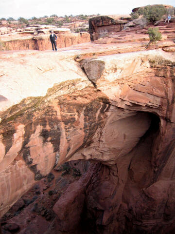
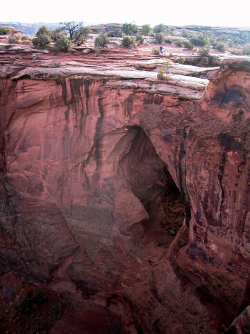
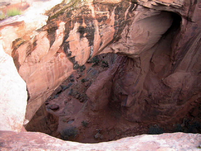
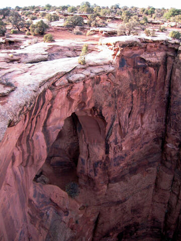
Gemini
Bridges are two large alcove type arches standing side-by-side. This is one of the most
popular mountain biking and and four wheel drive routes in the Moab area. |
General Information:
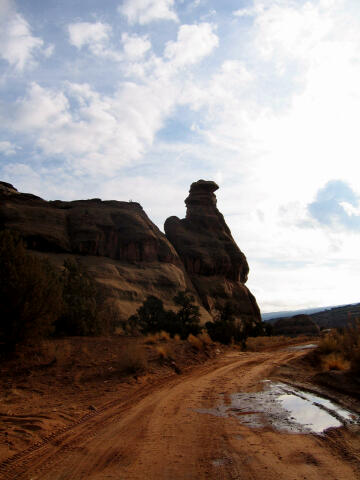
 Gemini Bridges is an easy adventure
the entire family can enjoy. This route is a popular mountain biking route and is suitable
for stock four wheel drive vehicles. The family SUV should have no problems with this
route. A visit to the top of Gemini Bridges from downtown Moab will require approximately
3 hours round trip to drive or 8 hours to mountain bike. It is 7.7 miles, one-way, from
where the pavement ends to the top of Gemini Bridges. Visiting the bridge from the top is
the most common method, but directions are also included for a visit to the bottom of the
arch for those who desire the full meal deal.
Gemini Bridges is an easy adventure
the entire family can enjoy. This route is a popular mountain biking route and is suitable
for stock four wheel drive vehicles. The family SUV should have no problems with this
route. A visit to the top of Gemini Bridges from downtown Moab will require approximately
3 hours round trip to drive or 8 hours to mountain bike. It is 7.7 miles, one-way, from
where the pavement ends to the top of Gemini Bridges. Visiting the bridge from the top is
the most common method, but directions are also included for a visit to the bottom of the
arch for those who desire the full meal deal.
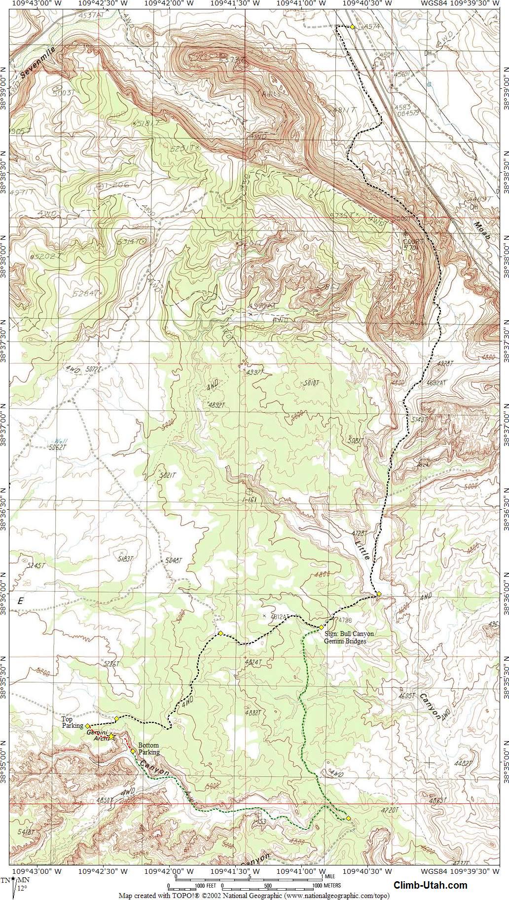
Navigation for this route
is easy. GPS waypoints are provided for convenience. There is nothing difficult about the
route. The USGS 7.5' Maps titled "Gold Bar Canyon" and "Merrimac
Butte" show the area. All waypoints and maps for this route use the WGS84 datum.
Caution:
Use
caution around Gemini Bridges, keep a close eye on children and foolish adults near the
cliffs. Several individuals have lost their lives here. At least two people
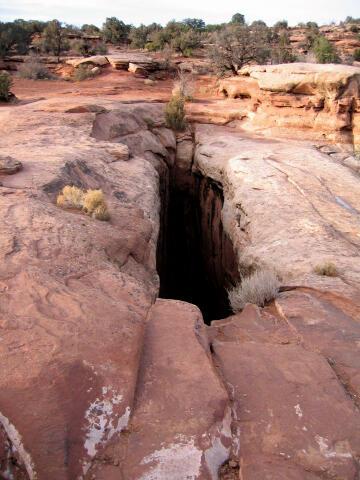
have fallen to their death
attempting to jump the 6-foot gap between the two spans. On October 9, 1999, Beau James
Daley, age 19, fell 160-feet from the outer span as he attempted to drive his jeep across
the bridge.
Statistics:
Gemini Bridge East
Greater Arch Dimension (GAD): 85.0 feet. For this arch, the GAD is its height.
Lesser Arch Dimension (LAD): 44.0 feet.
Gemini Bridge West
Greater Arch Dimension (GAD): 67.0 feet. For this arch, the GAD is its span.
Lesser Arch Dimension (LAD): 60.0 feet.
Trailhead Information:
From the bridge over the Colorado River, just outside Moab, drive north on Highway 191 for
7.2 miles to mile marker 135.5 and a large parking lot on the west (left) side of the road
(N38° 39' 22", W109° 40' 37"). The large parking lot is considered the trailhead for this adventure, if riding
a mountain bike this is where you will begin.
Route Information:
The area is criss-crossed with roads and tracks. Stay on the road described until
told to turn off of it. From the large parking lot, follow the well traveled dirt road
across the railroad track and bear south (left), continue following the wide dirt road.
The road climbs steadily until reaching a high point and swinging southwest, at which time
the road will descends into a wide valley. Soon you will pass Gooney Bird Rock. 4.7 miles
after leaving the large parking lot you will reach a tee (N38° 36' 0",
W109° 40' 25"), turn west (right) at the tee. Turn west (right) at the tee and climb
a steep hill, follow the road for 0.6 miles a sign that indicates Gemini Bridges west
(right) and Bull Canyon to the south (left).
Gemini Bridges From The Top:
At the Bull Canyon/Gemini
Bridges sign turn west (right) and follow the road 0.8 miles to a fork (N38° 35' 46,
W109° 41' 37"), turn south (left) and you will begin crossing slickrock. From the
fork follow the road and the painted white dashes across the slickrock for 1.2 miles to a
fork in the road (N38° 35' 16", W109° 42' 24"), bear south (left) and follow
the road for 0.2 miles to where a larger road (N38° 35' 13", W109° 42' 37")
enters from the north (right). This is a good place to park and walk the remaining
distance if you are in the family SUV. The final 1/4 mile to the bridge is difficult four
wheeling with big rocks and ledges. From the parking area follow the road north for 0.2
miles to Gemini Bridges (N38° 35' 09", W109° 42' 26").
Gemini Bridges From The Bottom:
At the Bull Canyon/Gemini
Bridges sign turn south (left) and follow the road 1.5 to a junction (N38° 34' 40, W109°
40' 39"). Turn north (right) at the junction and follow the the road. The road
follows a dry creek bed through a rocky ravine. The road splits and comes back together at
various locations. Just follow the most well traveled road up the canyon bottom. At 1.9
miles from the previous junction you will come to a small turnaround area (N38° 35' 04,
W109° 42' 17"). This is the best place to park and walk the final short distance to
the base of Gemini Bridges (N38° 35' 09", W109° 42' 26").
[ Homepage
] [ Introduction ] [ Warning ] [ Ratings
] [ Ethics ] [ Feedback ] [ Updates
]
© Copyright
2000-, Climb-Utah.com |