[
Homepage ] [
Introduction ] [
Warning ] [
Ratings
] [ Ethics ] [
Feedback ] [
Updates ]
 |
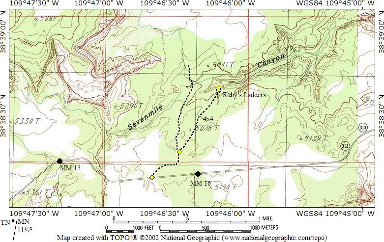
Ruby's Ladder
& Cable Tramway
Moab
Mining Relic
Ruby's
Ladder and Tramway is an interesting relic left from 1903. This is a
roadside attraction the entire family can enjoy. The adventure is a nice
way to spend a few minutes and ponder what life on the Colorado Plateau
was like in the early 1900's. |
General Information:
 Ruby's Ladder and Tramway is located at the head of Seven Mile Canyon and can easily be visited by all family members.
A trip to explore the area requires
about 15 minutes. Binoculars are useful for viewing the lower ladder and
tramway. The relic is accessible year round in all weather conditions.
Ruby's Ladder and Tramway is located at the head of Seven Mile Canyon and can easily be visited by all family members.
A trip to explore the area requires
about 15 minutes. Binoculars are useful for viewing the lower ladder and
tramway. The relic is accessible year round in all weather conditions.
A GPS is useful in verifying you are at the correct location. The USGS 7.5'
Map titled "Jug Rock" shows the area described. All waypoints and maps use the WGS84 datum.
This roadside attraction is a short stop for anyone visiting Dead Horse
Point State Park or the Island in the Sky District of Canyonlands National
Park.
History:
From what I have been
able to learn so far it appears the ladders and cable tramway were built by
Glen Ruby in 1903. I'm not sure what the system was used for but I'm
guessing the cable tramway was used to bring water up to the canyon rim
because the tramway bottoms out next to a spring. I assume the ladders were
used to service the tramway. I have been told the water was used for
drilling on the top of the mesa, but I have not been able to verify any of
this information.
 |
 |
Trailhead Information:
This roadside
attraction is
located just outside of Moab on the road to Dead Horse Point and Canyonlands
Island in the Sky District. The trailhead is accessible to all vehicles,
year round, via a paved highway.
From Moab head north out
of town on U.S. Highway 191. Cross the bridge over the Colorado River. After
crossing the bridge continue north for 8.3 miles to the junction with State
Road 313, signed Dead Horse Point and Canyonlands. Turn west (left) on State
Road 313 and follow it for 6.8 miles to mile marker 15.7 (N38° 38' 08",
W109° 46' 36") and a dirt road exiting the north (right) side of the
highway. Those with passenger cars might want to park here and hike the
remaining distance. Those with a high clearance vehicle should have no
problem driving right to the top of the tramway.
From the paved highway, follow the dirt road north for 0.3 miles to a fork
in the road (N38° 38' 17", W109° 46' 24"). Take the east
(right) fork and continue following the dirt road an additional 0.5
miles to where the road ends. This is the trailhead and is identified by and
old A-frame and timbers on the ground that made up the top of the tramway.
 |
 |
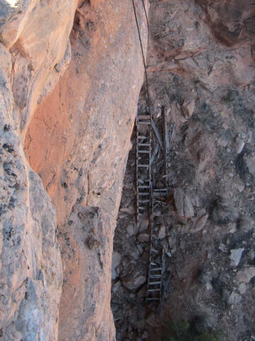
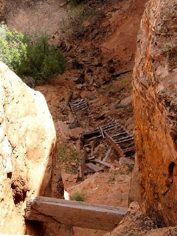
Route
Information:
There is no hiking
involved with this route unless you are extremely energetic and feel like
scrambling down the cliffs to the base of the old tramway. Everyone else
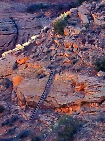
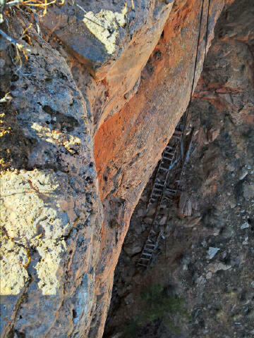
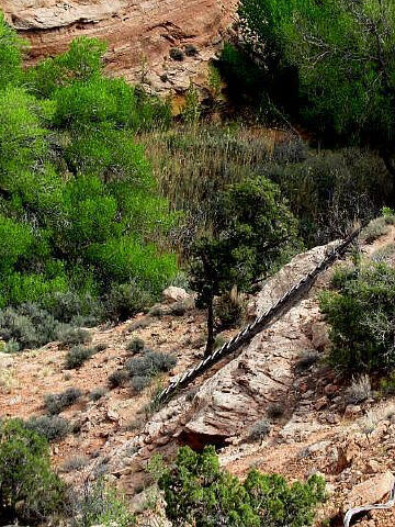
will want to explore the area from the canyon rim. The tramway has fallen to
the ground, but the cables are still present and define the route, which
bottoms out at a spring. Originally there were two long wooden ladders that
provided easy access through the cliff bands. The upper ladder has now
fallen and is easy to locate if you look over the cliff from the trailhead.
The second ladder is still standing intact and is best seen from the rim by
walking around to the head of Seven Mile Canyon. Please take only pictures and leave
only footprints.
[
Homepage
] [ Introduction ] [
Warning ] [
Ratings ] [
Ethics
] [ Feedback ] [
Updates ]
© Copyright
2000-, Climb-Utah.com |