[ Homepage ] [ Introduction ] [ Warning ] [ Ratings ] [ Ethics ] [ Feedback ] [ Updates ]
  The Ding & Dang Canyon loop hike is 5 miles round
trip and will take 3 to 4 hours to complete. The easiest route is to climb up Ding Canyon
and descend Dang Canyon. This is a desert environment so carry plenty of drinking
water. There is some scrambling and minor downclimbing involved with this
hike. Navigation is required and there is no developed or signed trail. Most
obstacles can be easily bypassed if you spend a moment and look for a way around
them. I suggest bringing a 30-foot rope for belays, lowering packs and possible emergency
use. Ding & Dang Canyons are rated 2A II using the Canyon Rating System.
The Ding & Dang Canyon loop hike is 5 miles round
trip and will take 3 to 4 hours to complete. The easiest route is to climb up Ding Canyon
and descend Dang Canyon. This is a desert environment so carry plenty of drinking
water. There is some scrambling and minor downclimbing involved with this
hike. Navigation is required and there is no developed or signed trail. Most
obstacles can be easily bypassed if you spend a moment and look for a way around
them. I suggest bringing a 30-foot rope for belays, lowering packs and possible emergency
use. Ding & Dang Canyons are rated 2A II using the Canyon Rating System.
Improved campgrounds with modern toilets and hot showers are located nearby in Goblin Valley State Park. The canyons can be hiked year round except when thunderstorms are possible. Spring and Fall are the preferred hiking seasons. Hiking during the summer can be very hot. These canyons have a flash flood potential and caution should be used. Usually there is some water in the narrows so wear shoes that you can wade in. Under normal conditions knee deep wading is all that is required, skilled canyoneers can avoid this by stemming over the water. I have completed this hike immediately after a heavy rainstorm and encountered knee deep water in Ding Canyon and chest deep water in Dang Canyon. A GPS is useful in identifying the correct trailhead and checking that you are on course. Navigation for this route is easy. Good map reading skills and the USGS 7.5' Map titled "Little Wild Horse Mesa" are essential. This hike can be completed in the reverse direction of what is described here if you are looking for a more difficult challenge. You need to climb at about a 5.7 level to complete the route in the reverse direction. CLICK HERE if you want to read a first hand account of being caught in a flash flood in the San Rafael Swell. A Word of Caution:
Ding & Dang Canyon is located in Emery County between the towns of Green River and Hanksville. From Green River, Utah follow I-70 west for 11 miles to Exit #149 and Highway 24. Follow Highway 24 south for 24 miles to mile maker 136 and the signed turn-off to Goblin Valley State Park. Follow the signs to Goblin Valley State Park. The signed turn-off to Little Wild Horse Canyon is located 11 miles from Highway 24 and 2 miles before the Goblin Valley State Park fee station on the west side of the road. Follow the well maintained dirt road for 5.3 miles to the Little Wild Horse Trailhead, continue past the Little Wild Horse Trailhead for 1.3 miles to where a large wash comes in on the right and the road turns south and heads toward Wild Horse Mesa. There is a small parking area on the west side of the road with a stand of cottonwood trees located a short distance up the wash. The trailhead can be reached by passenger car in good weather.
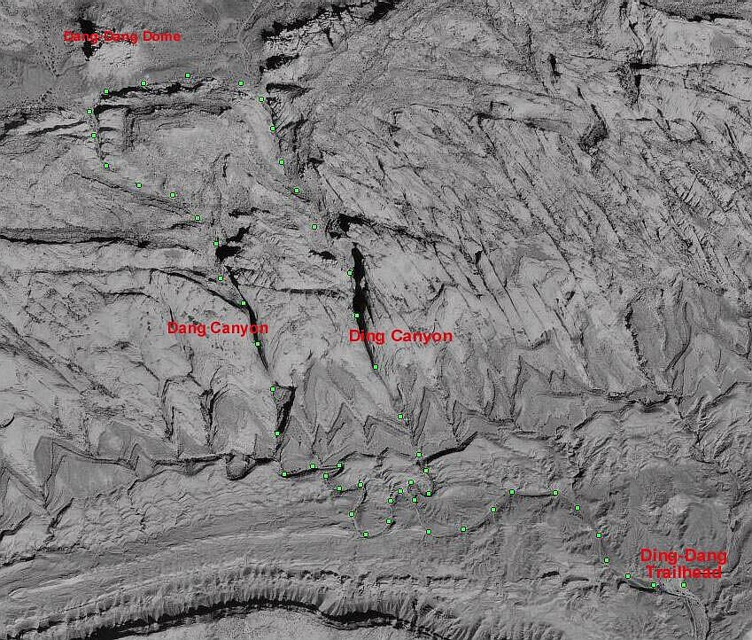 From
the trailhead (N38° 34' 36", W110° 49' 18") begin hiking west up the large
wash past the cottonwood trees. The route snakes along the front of the reef for about 1
mile until arriving at the Ding & Dang Canyon junction (N38° 34' 48", W110° 50'
08"). A ridge divides the wash with the right fork leading into Ding Canyon and
the left into Dang Canyon. You will know you are at the correct junction if there is
a large cedar tree guarding the entrance to Ding Canyon. Take the right fork past the
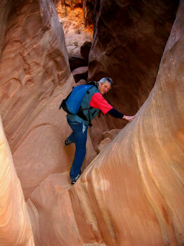
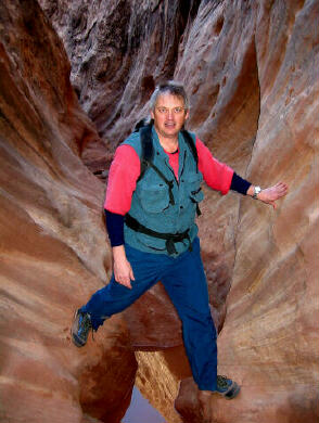
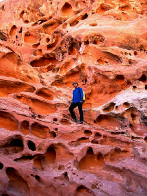
cedar tree into Ding. The route soon arrives at the first section of narrows and begins
climbing to the backside of the reef. There are many obstacles but none are difficult if
you search for a path. Near the top of the reef you will encounter a beautiful
section of potholes. These can all be easily bypassed by climbing the ledge systems
round them. From
the trailhead (N38° 34' 36", W110° 49' 18") begin hiking west up the large
wash past the cottonwood trees. The route snakes along the front of the reef for about 1
mile until arriving at the Ding & Dang Canyon junction (N38° 34' 48", W110° 50'
08"). A ridge divides the wash with the right fork leading into Ding Canyon and
the left into Dang Canyon. You will know you are at the correct junction if there is
a large cedar tree guarding the entrance to Ding Canyon. Take the right fork past the
cedar tree into Ding. The route soon arrives at the first section of narrows and begins
climbing to the backside of the reef. There are many obstacles but none are difficult if
you search for a path. Near the top of the reef you will encounter a beautiful
section of potholes. These can all be easily bypassed by climbing the ledge systems
round them.
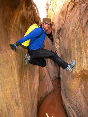
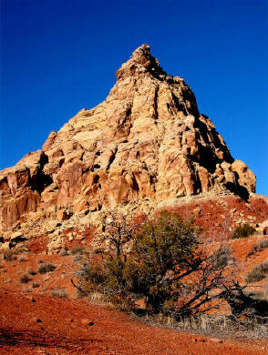
At the top of Ding Canyon (N38° 35' 47", W110° 50' 37") follow the faint trail west over a small rise between the reef and Ding Dang Dome, which is a tall pyramidal shaped rock butte. After the rise you begin dropping into Dang Canyon (N38° 35' 45", W110° 51' 09") and head downstream. You will soon reach a 40-foot dryfall with a 20-foot dry fall just below. Both of these obstacles can be easily bypassed using the ledge system on the right (west) looking down canyon. From the lip of the dryfall walk up canyon 15 feet and the ledge system begins behind a bush. The ledge looks narrow in one section but there are excellent handholds. Below this there are several chokestones that require scrambling and a small amount of downclimbing to get around. Near the bottom of the canyon you will encounter a section of narrows and perhaps some water. When you exit the front of the reef (N38° 34' 58", W110° 50' 34") just follow the wash 1 1/2 miles back to the parking area. GPS Coordinates If you use a GPS when hiking, the following coordinates eliminate all navigation difficulties associated with this hike. Name Latitude
Longitude
Description [ Homepage ] [ Introduction ] [ Warning ] [ Ratings ] [ Ethics ] [ Feedback ] [ Updates ] © Copyright 2000-, Climb-Utah.com |