 Eardley Canyon is a technical canyoneering adventure
that will require approximately 7 hours to complete. You will require complete technical gear along with a 100-foot rope,
several slings and a drybag for your gear. Helmets are strongly recommended. The route
contains 5 rappels, all less than 50 feet in height.
Eardley Canyon is a technical canyoneering adventure
that will require approximately 7 hours to complete. You will require complete technical gear along with a 100-foot rope,
several slings and a drybag for your gear. Helmets are strongly recommended. The route
contains 5 rappels, all less than 50 feet in height.
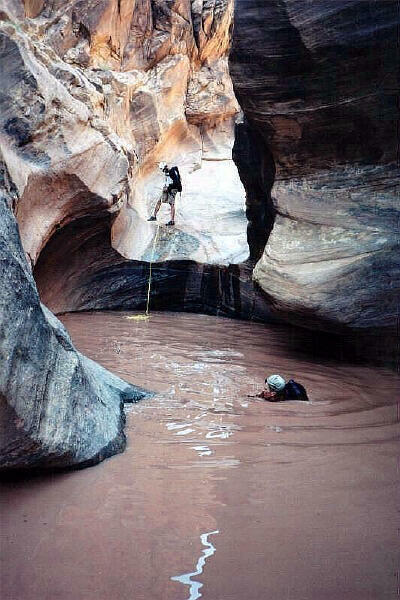
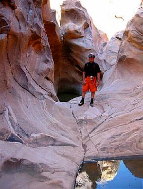
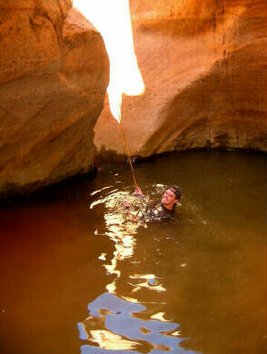
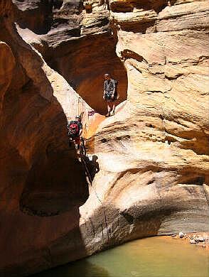
Eardley Canyon is rated 3B III using the Canyon Rating System. Eardley Canyon drains a large area, which translates into a high flash flood danger, check the weather report before entering this canyon. Leave your bolt kit at home. This canyon is already extremely over bolted. There are plenty of natural anchors at every rappel. Bring 50 feet of extra webbing, a couple of slings and a few rappel rings and you can eliminate the extra weight of a bolt kit. This canyon requires swimming and wading. The water is bathtub warm during hot weather; a wetsuit will be required during cool weather and by the cold blooded. The fun factor in this canyon is usually measured by the current water level. The higher the water level the higher the fun factor. Descending this canyon within a week of it flashing will provide maximum enjoyment so keep an eye on your Doppler radar. I suggest a group size of six or less since you must downclimb a long loose gully and a large group will greatly increase the odds of braining your companion with a rock. This gully downclimb is also the reason I strongly recommend helmets for this adventure. "Arsons Garden" and "Greasewood Draw" are the USGS 7.5 minute topographical maps that show Eardley Canyon. There is some navigation required for this adventure and a GPS is helpful, but not required. All waypoints and maps for Eardley Canyon use the WGS84 datum. Always check your GPS to ensure that WGS84 is the datum before entering a waypoint into your unit.
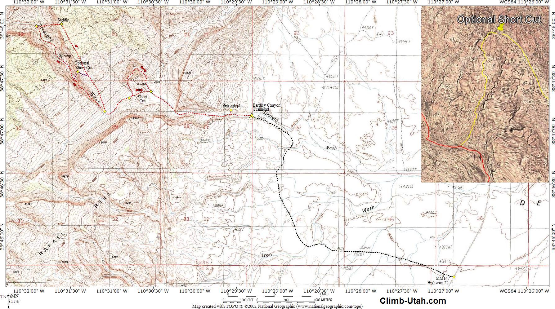
Eardley Canyon is located in Emery County between the towns of Green River and Hanksville. From Green River, Utah follow I-70 west for 11 miles to Exit #149 and Highway 24. Follow Highway 24 south for 13 miles to mile marker #147. Turn west on the good dirt road. Follow the dirt road to its end in 3.7 miles. Approximately 1 1/4 miles after leaving Highway 24 the dirt road crosses Iron Wash and splits in several directions but all the roads rejoin on top of the hill so pick the road in the best condition. There are several primitive campsites in the area of the trailhead. A four wheel drive or high clearance vehicle is required to reach the actual trailhead. Passenger cars can be driven down the dirt road for approximately 1 1/4 miles but are normally stopped by a rough section just before the dirt road crosses Iron Wash.
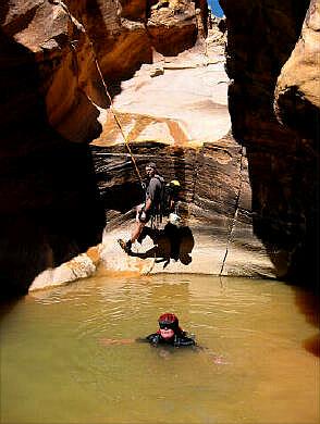
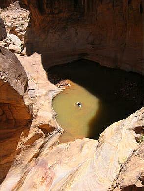
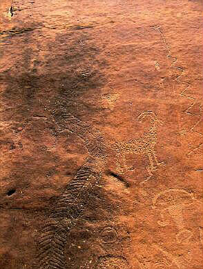
From the trailhead (N38° 47' 09", W110° 29' 19") follow Straight Wash west into the reef. Within a few hundred yards of the trailhead you will encounter signs stating "No Vehicles beyond this point". 100-yards beyond the signs there are two very good petroglyph panels (N38° 47' 12", W110° 29' 34") on the right side of the canyon. The panels are located behind some bushes just after you round the corner. Among the many images on the panels are a Kokopelli and a large unique snake with a freaky head. Continue hiking up Straight Wash until you reach the mouth of Eardley Canyon located on your right (LUC). Eardley Canyon is very narrow where it enters Straight Wash and is easy to miss if you are watching your shoes and not paying attention. From the Trailhead to Eardley Canyon is 2 1/4 miles and will require 1 hour of hiking time if you follow Straight Wash for the entire distance. There is a short cut (N38° 47' 23", W110° 30' 32"), but I suggest you hike the interesting Big Bend of Straight Wash on the approach and use the short cut on the return. The short cut saves 15 minutes of hiking. From the mouth of Eardley Canyon (N38° 47' 11", W110° 31' 05") walk back downstream 50-feet and begin climbing up the face of the reef on the northeast side of Eardley Canyon. Route finding is never a major problem, just look for the easiest way and stay close to the canyon as you continue up the reef. You will be rewarded with several excellent views into the bottom of Eardley Canyon as you climb. If you look across Straight Wash you will see several old uranium mines. From the mouth of Eardley Canyon continue up the reef for approximately 1 1/2 hours until you come to a distinct saddle (N38° 48' 01", W110° 31' 37"). The saddle is easy to locate since everything seems to funnel into it as you get near. Climb through the saddle and descend a steep, narrow, class 3 gully to the floor of Eardley Canyon. It will require 1/2 hour to descend the gully. You will lose 800 feet of elevation from the saddle to the canyon bottom. The gully will be nice and shaded if you got an early start. The gully is steep and contains loose rock. It is much easier and safer to descend this area if you stay 30 to 100 feet north of the gully and route find your way down through the rock bands. Once you have reached the floor of Eardley Canyon (N38° 48' 00", W110° 31' 55") just head downstream and let the fun begin. If there has been recent rains you might begin to encounter wading and swimming shortly after beginning down Eardley Canyon. After a bunch of bouldering, wading and perhaps swimming you will reach the first rappel. The first rappel is 25 feet down a mild slope into a pool of water. The rappel anchor is a bolt station located around the corner to the left (LDC) of the stream flow. The anchor point requires a little scrambling to reach. This is perhaps the most candy ass rappel in the San Rafael Swell. Using a little teamwork anyone can safely downclimb this drop. The second rappel is 25 feet into a pool of water. The rappel anchor is a bolt station located to the right (LDC) of the stream flow. The second rappel drops you into a deep pothole that can be difficult to exit for a solo canyoneer. Most people are able to climb out with little problem. Two people should have no problem exiting this pothole if they use a little teamwork. Do not pull your rappel rope until one member of your party has safely exited the pothole. The third rappel is 30 feet into a pool of water. The rappel anchor is a bolt station located to the right (LDC) of the stream flow. This rappel deposits you in a pool of water that is easy to exit if you use the small, easy to identify, diagonal ledge exiting the pothole. The fourth rappel is 8 feet into a pool of water. The rappel anchor is a bolt station located to the right (LDC) of the stream flow. It is very tempting to jump into this pothole and ignore the rappel but I would advise against doing so. The depth of this pool varies greatly with recent weather conditions. If you really want to jump into this pothole I suggest lowering the first member of your party over with a rope so they can decide if the pool is deep enough to allow jumping and if there is a safe place to land. The fifth rappel is 50 feet into the huge pool of water at the bottom of Eardley Canyon. This pool is spring feed and always full. The rappel anchor is a chokestone wedged into the watercourse. If the water is high you might need to feel 6" under the water to locate the webbing and rappel rings. There is also a chokestone to the left (LDC), which could be easily slung to provide a rappel anchor. After exiting the final pool of water must groups find it relaxing to arrange gear, grab a snack and if the weather is hot to take a final swim before heading back to the trailhead. Hike out to Straight Wash and head back to the trailhead. 1/4 mile after leaving the mouth of Eardley Canyon you will notice a trail leading east through a low saddle (N38° 47' 19", W110° 30' 48"). This is a short cut back to the trailhead that will save you 15 minutes of hiking. Optional Short Cut: Recently an Optional Short Cut has become popular for entering Eardley Canyon. The short cut can eliminate a couple hours of hiking the least desirable section of the route. The Optional Short Cut requires advance route finding skills and some 4th class scrambling. The exposed sections of scrambling can be protected with a belay from above or a spot from below. To reach the Optional Short Cut (N38° 47' 34", W110° 31' 25") you hug the rim of Eardley Canyon until you are cliffed out. The top part of the route is the sketchiest because the cliff bands below you are intimidating. Stay level from where the rim cliffs out and hike above a good-sized juniper tree straight ahead of you, then drop down a short rock slide area to a point where you can downclimb the cliff bands. Once past the short downclimb, it's hiking and easy scrambling to reach the canyon bottom. The route just requires a bit of commonsense and sensible route finding, don't climb down anything you can't reverse and you should be safe The Optional Short Cut deposits you just above the start of the technical section of Eardley Canyon.
Video: © Copyright 2000-, Climb-Utah.com |