[ Homepage ] [ Introduction ] [ Warning ] [ Ratings ] [ Ethics ] [ Feedback ] [ Updates ]
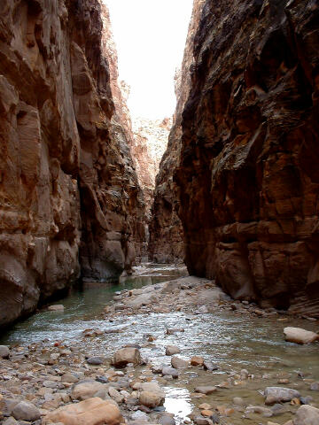
   The Chute of Muddy Creek is
a non-technical canyoneering adventure. The route is 15 miles long and will require 8 to
10 hours form trailhead to trailhead. April/May and September/October are the preferred
times of year to do this hike. I have heard rumors of nasty horseflies and other bugs in
the summer months but never experienced them. I have also hiked Muddy Creek during
December and other than cold feet it was a great time.
The Chute of Muddy Creek is
a non-technical canyoneering adventure. The route is 15 miles long and will require 8 to
10 hours form trailhead to trailhead. April/May and September/October are the preferred
times of year to do this hike. I have heard rumors of nasty horseflies and other bugs in
the summer months but never experienced them. I have also hiked Muddy Creek during
December and other than cold feet it was a great time.
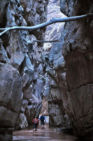
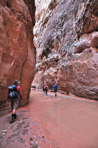
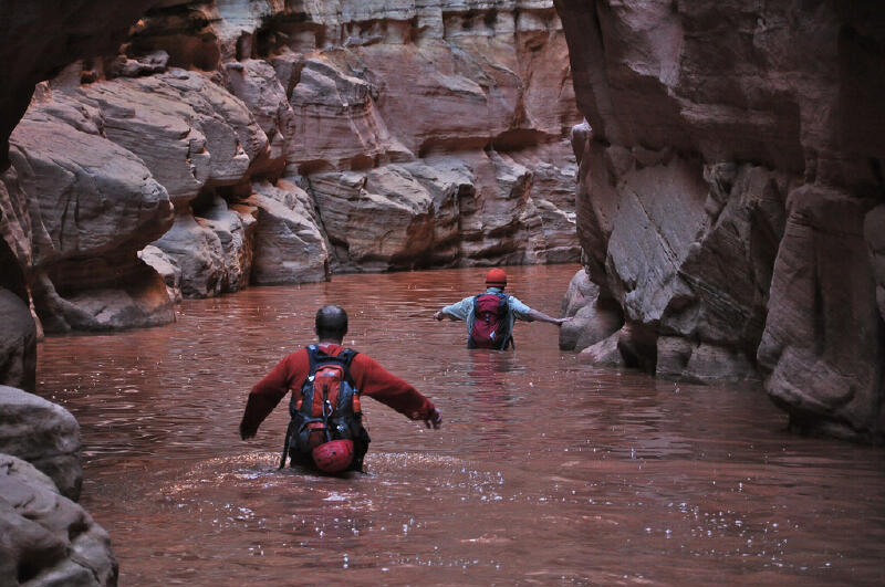
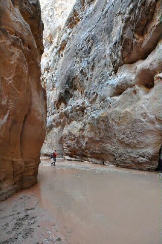
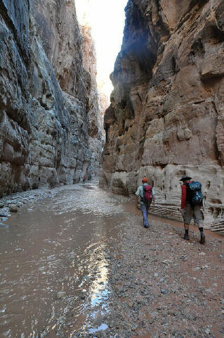
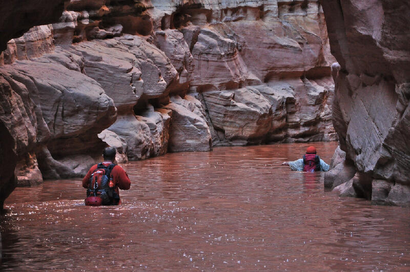
A 16-mile car shuttle is required to complete this route. If you are really hardcore it is possible to use a mountain bike shuttle as your shuttle vehicle. A mountain bike shuttle will add 1:30 to your adventure. Under normal conditions the water in The Chute is never more than waist deep and usually only ankle deep, but don't be surprised if you encounter a section of chest deep water or even a short swim. This is a slot canyon, conditions change with every major storm. You will be wading in ankle deep water for approximately half the route. The hiking is easy with hardly any noticeable gain or loss in elevation. A walking stick or trekking poles are highly advised for this adventure. The creek bottom alternates between pebbles, gravel, sand, clay and boulders. Although this route normally requires no swimming it would still be prudent to pack whatever you want to keep dry into drybags and to bring a warm jacket. Neoprene socks worn inside your shoes will help keep your feet warm in colder weather. During high spring runoff this route will be much more difficult. High water through this canyon usually lasts only a couple of weeks but caution and sound judgment should always be used. The USGS provides real-time stream flow data for the Muddy River near Emery, Utah. Unfortunately the river gage at Emery is not a true measure of what you will find in The Chute since the farmers upstream divert some water. I have done this hike when the Emery gage had a reading of 150 cfs. At 150 cfs on the Emery gage the hiking begins to get difficult. The USGS 7.5
minute topographical maps required for this hike are "Tomsich Butte" and
"Hunt Draw". Navigation for this adventure is easy, but there is no real trail.
You will be walking and wading in a canyon bottom. A GPS is useful in identifying the
correct trailhead and checking that you are on course. All waypoints and maps for this
route use the WGS84 datum. The Chute of Muddy Creek is rated 1C III using the Canyon
Rating System.
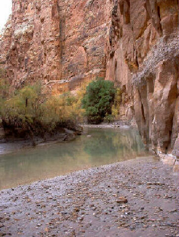
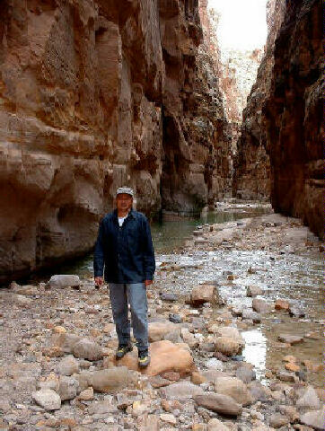
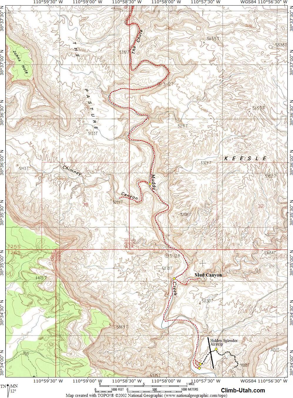
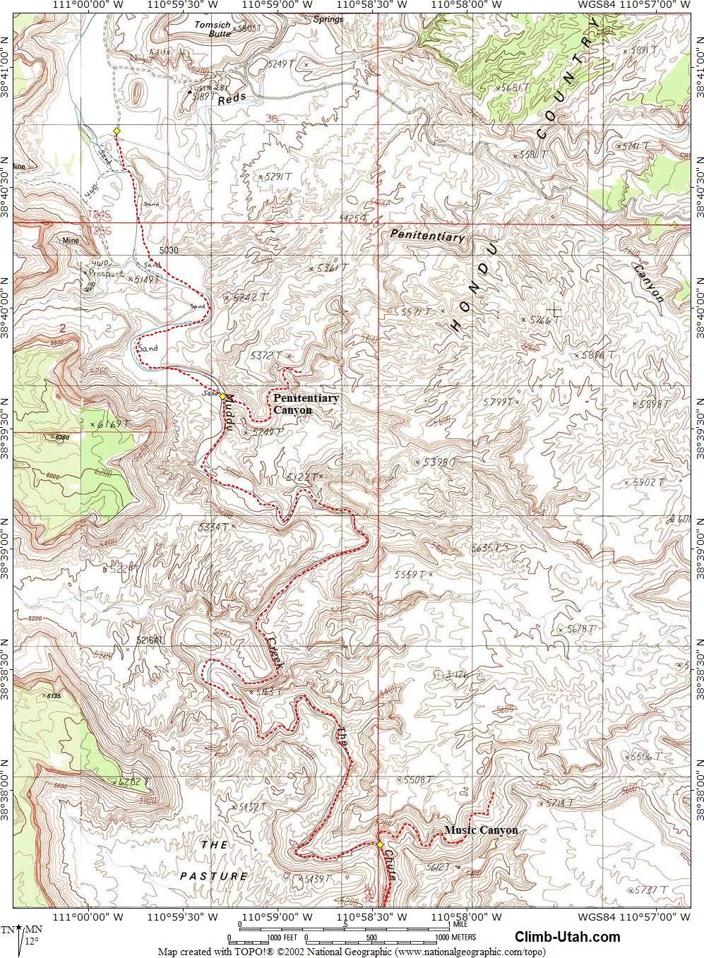
Any vehicle during good weather can normally access the trailheads required for this hike. A shuttle vehicle is mandatory. The San Rafael Swell is criss-crossed with roads. Stay on the road described until told to turn off of it. From Green River, Utah follow I-70 west for 29 miles to the underpass at mile marker #131. From the cattle guard on the south side of the underpass, follow the graded dirt road signed U24/Goblin Valley/Temple Mountain, for 10.2 miles to the signed Red Canyon/Tan Seep junction. Take the right (west) fork for 3.8 miles to the signed Red Canyon/Mckay Flat junction. Turn right (west) and follow the road for 0.9 miles to the signed Mckay Flat junction. Take the left (South) fork for 8.6 miles to the signed Hidden Splendor Mine junction. At the Hidden Splendor Mine junction, The right (west) fork leads to Tomsich Butte and the left (south) fork leads to the Hidden Splendor Mine. Remember this junction because we will return to it after dropping off our shuttle vehicle at the Hidden Splendor Mine. From the Hidden Splendor Mine junction take the south fork toward Hidden Splendor Mine. Follow the road for 10.2 miles to the Hidden Splendor Airstrip (N38° 34' 07", W110° 57' 25"). The airstrip is identified by an information kiosk and a wind sock. The Hidden Splendor Airstrip is where the route ends and is where you leave a shuttle vehicle. Near the Hidden Splendor Airstrip is a great place to camp with spectacular views of the Muddy River Gorge. The Hidden Splendor Mine contains numerous relics to explore. Do not park or camp on the airstrip. The Hidden Splendor Airstrip is an official aircraft landing strip operated by the BLM and the Utah Backcountry Pilots association. Aircraft may be encountered at any time. Any interference with aircraft or aircraft operations is a federal crime. Return 10.2 miles to the Hidden Splendor junction you were at earlier. From the junction take the west fork of the road and follow it for 5.1 miles to Tomsich Butte junction. The main road goes north at the junction but continue straight ahead (west) for 0.6 miles to a track leading south. Follow this track south for 0.3 miles to where it reaches the Muddy River. This is the Tomsich Butte Trailhead (N38° 40' 43", W110° 59' 52"). Tomsich Butte is a fun place to camp with secluded camping in the tamarisk lining the Muddy River. Hondoo Arch is clearly visible on the canyon rim to the west above the Eagle and Big Chief Mines. The Dirty Devil Mine at Tomsich Butte is located less than 1 mile back up the road, you probably noticed it as you drove to the trailhead. These mines all contain numerous and interesting relics left from the Uranium boom of the 1950's. For your safety I suggest you stay out of the mines and please take only pictures and leave only footprints.
Route Information: The first part of the route is just an interesting stroll down a river bottom for 2 miles to where Penitentiary Canyon (N38° 39' 37", W110° 59' 17") enters from the east (left). Penitentiary Canyon received it's name because early cattle ranchers would heard cattle up the canyon from the Muddy River and the cattle could not get out. After leaving Penitentiary Canyon the fun begins to slowly build as the canyon starts to narrow up and get exciting. From Penitentiary Canyon it is 5 1/4 miles to where Music Canyon (N38° 37' 46", W110° 58' 28") enters from the east (left). Explore up the narrow slot that forms Music Canyon and return. Downstream from Music Canyon you will pass through the narrowest sections of The Chute. For the next 4 1/4 miles you will be walking through spectacular and exciting narrows until you reach the mouth of Chimney Canyon (N38° 35' 47", W110° 58' 13"), which enters from the west (right). Chimney Canyon received its name from a rock formation that looked like a chimney. From Chimney Canyon it is 1 1/2 miles downstream to the mouth of Mud Canyon (N38° 34' 51", W110° 57' 54") entering from the east (left). From Mud Canyon it is 1 1/2 miles downstream to where an easily visible track (N38° 33' 59", W110° 57' 41") begins winding its way up the east (left) cliff. Follow the track up the cliff for 1/2 mile to the Hidden Splendor Airstrip (N38° 34' 07", W110° 57' 25").
Technical Route Information: Optional Route
Information:
Dirty Devil Mine: Vernon Pick, a middle-aged electrician from Minnesota, discovered the Delta Mine (Hidden Splendor) northwest of Hanksville in 1952. Vernon Pick reaped one million dollars from the mine before he sold it two years later to international financier Floyd Odlum's Atlas Corporation for $9 million and a custom-converted PBY airplane. In November 1954 Life Magazine published and 11-page article titled "Vernon Pick's $10 million Ordeal" that detailed the discovery of the Delta Mine. Publicity from this article greatly increased prospecting in the San Rafael Swell and surrounding Colorado Plateau and made the Delta Mine famous. Floyd Odlum renamed his new purchase the Hidden Splendor Mine. Odlum was certain the mine was a rich find and his geologists estimated the mine held 540,000 tons of uranium ore with an in-place value of forty dollars per ton. This would have made the mine worth nearly 22 million dollars. However, the Atlas Corporation only extracted 90,000 tons of ore from the mine before abandoning it in 1957. Local wags then dubbed the mine "Odlum's Hidden Blunder". After Atlas Corporation left several others tried unsuccessfully to extract ore. The Uranus Corporation took over the mine for a short time in cooperation with Central Oil. The Hidden Splendor Mine closed in 1957 and was eventually sold for taxes.
Kayak and Canoe: Related Links: [ Homepage ] [ Introduction ] [ Warning ] [ Ratings ] [ Ethics ] [ Feedback ] [ Updates ] © Copyright 2000-, Climb-Utah.com |