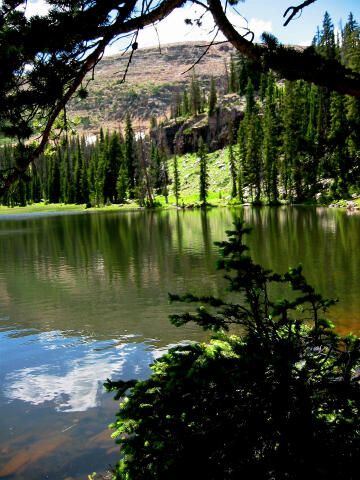
 The Fehr Lake hike is an
adventure the entire family can enjoy. The scenic route visits the lovely Fehr Lake.
Backpacking in this area is not the best. Fehr Lake is to close to the road to be much of
a wilderness experience except perhaps with small children. It is possible to visit Hoover
and Marshall Lakes by ATV using the Murdock Basin Road. This fact diminishes the
wilderness backpack experience but does not detract from day hiking the route. Shepard
Lake or one of several meadows is the best option for backpacking in this area.
The Fehr Lake hike is an
adventure the entire family can enjoy. The scenic route visits the lovely Fehr Lake.
Backpacking in this area is not the best. Fehr Lake is to close to the road to be much of
a wilderness experience except perhaps with small children. It is possible to visit Hoover
and Marshall Lakes by ATV using the Murdock Basin Road. This fact diminishes the
wilderness backpack experience but does not detract from day hiking the route. Shepard
Lake or one of several meadows is the best option for backpacking in this area.
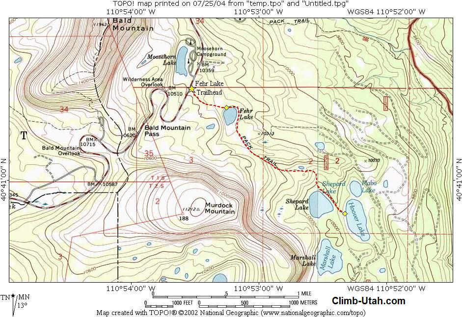
The basic round trip hike to Fehr Lake can be completed in less than 1/2 hour. It would be easy to spend an entire day in the area exploring all of the lakes in the area. A vehicle shuttle is not required, this is an out and back hike. All hikers in your party should carry a minimum of one liter of water. Water is plentiful in this area, but all water taken from lakes and streams should be filtered before drinking. The route contains no real obstacles. Novice hikes will have no problems with this route. Experienced and intermediate hikers can easily entertain themselves with several hikes to secluded lakes in the area. The Fehr Lake Route is rated 1 I using the Yosemite Decimal System. Afternoon thunderstorms are very common in the high Uinta Mountains so go prepared with rain gear. Because of the high precipitation mosquito's are common in the Uinta's. A mosquito repellent that contains DEET (N,N-diethyl-m-toluamide) is most recommended. Navigation for this route is easy. A GPS is useful in identifying waypoints if you intend to travel cross-country to any of the secluded lakes. Good map reading skills and the USGS 7.5' Maps titled "Mirror Lake" and "Hayden Peak" are helpful. All waypoints and maps for this route use the WGS84 datum. Use
Fee:
Fishing: Trailhead
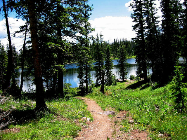
Information: From Evanston, Wyoming follow Highway 150 south for 48 miles to the Fehr Lake Trailhead located at mile marker 30.5. The large parking area at Fehr Lake Trailhead is dirt and is not signed. It is easy to located because it is almost directly across Highway 150 from the popular Moosehorn Campground. Any vehicle can access this trailhead. Route Information:At the southwest corner of the parking area there is a sign pointing the way to Fehr, Shepard and Hover Lakes. The sign states that it is .5 miles to Fehr Lake but it is in error. The trail is only slightly over 1/4 mile in length. From the Fehr Lake Trailhead (N40° 41' 33", W110° 53' 53") follow the well-maintained trail east for 1/4 mile to Fehr Lake (N40° 41' 26", W110° 53' 32"). The trail is easy to hike and very scenic as it passes near a meadow. Murdock Mountain to the South and Bald Mountain to the east provide an impressive backdrop. Experienced Hiker
Options: © Copyright 2000-, Climb-Utah.com |