[ Homepage
] [ Introduction ] [ Warning ] [ Ratings
] [ Ethics ] [ Feedback ] [ Updates
]
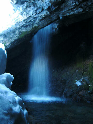 |
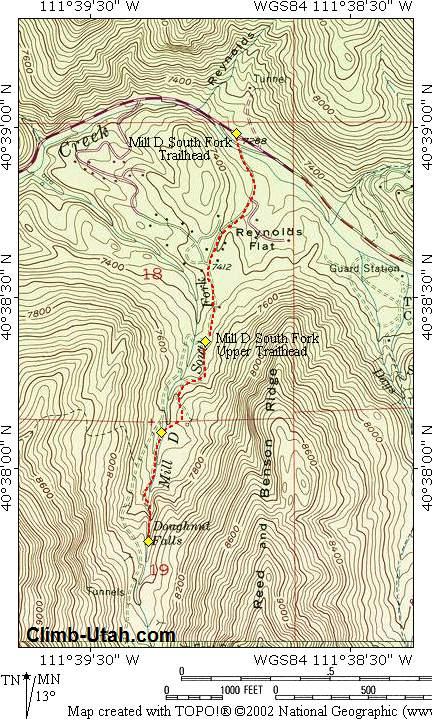
Donut Falls
Mill D - South Fork
Big Cottonwood Canyon
Wasatch Mountains
Hiking & Snowshoeing
Donut Falls, shown on USGS maps as Doughnut Falls, is a fun and easy hike in summer and a
spectacular snowshoe adventure in winter.
Donut Falls
was closed to public access from 2004 through 2006. The falls were purchased by Salt Lake
County in 2007 and are once again open to public access. |
General Information:
 Donut Falls is a fun and popular
hike. The trail to Donut Falls is 1 3/4 miles
one-way and will require approximately 1 hour to reach the waterfall from the trailhead.
This is one of the more popular hikes in the Wasatch Mountains.
Donut Falls is a fun and popular
hike. The trail to Donut Falls is 1 3/4 miles
one-way and will require approximately 1 hour to reach the waterfall from the trailhead.
This is one of the more popular hikes in the Wasatch Mountains.
All hikers in your party
should carry a minimum of one liter of water. Water is plentiful in this area, but all
water taken from lakes and streams should be filtered before drinking.
The route contains no real
obstacles. This route is suitable for beginners. Donut Falls is rated 1 II using the
Yosemite Decimal System. Navigation for this route is easy. A GPS is useful in identifying
waypoints and verifying your location. Good map reading skills and the USGS 7.5' Map
titled "Mount Aire" is helpful. All waypoints and maps for this route use the
WGS84 datum. It should be noted that due to new trail construction and trail realignment
the USGS maps are not accurate in relation to trail location. The trails are correctly
located on the map provided.
Big Cottonwood Canyon is
within Salt Lake City Watershed, therefore special restrictions apply and are strictly
enforced. No domestic animals (dogs, cats, horses) are permitted in Big Cottonwood Canyon.
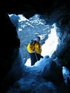
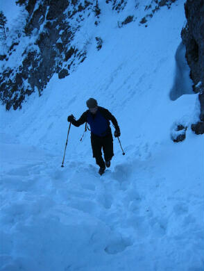
Snowshoe Rentals:
This
is a perfect chance for any hiker to discover the fun of snowshoes. Most ski rental
shops in the Salt Lake valley rent snowshoes for about $10 per day.
Winter Warning:
During
the winter months the Mill D area is a popular snowshoe destination. Avalanche danger
should always be a major priority and proper precautions should be taken when enjoying
Utah's winter wonderland. The Donut Falls trail is not prone to avalanche, but it is
always better to be safe than sorry when traveling in Utah's winter
backcountry. Check with the
Utah Avalanche
Center for current conditions before attempting this route in winter.
Trailhead Information:
From anywhere in the Salt lake Valley take I-215 East until you reach the 6200 South Exit
(Exit 6). Signs are marked for the ski areas, you will be heading towards Brighton and
Solitude Ski Resorts. Drive east on 6200 south and the road will become Wasatch Boulevard.
Follow Wasatch Boulevard south to an intersection with Fort Union Boulevard (7200 South).
The intersection is located 1.7 miles after exiting I-215.
All mileage is taken from the
intersection of Wasatch Boulevard and Fort Union Boulevard. This is known locally as the
"Mouth of Big Cottonwood Canyon". There is a large Park and Ride lot with
restrooms located near the north east corner of the intersection.
From the intersection drive east up
Big Cottonwood Canyon. After driving 9.1 miles you will reach the signed "Mill D
Trailhead". This is a large paved parking lot located on both the north and south
side of the road. Information kiosks are located on both sides of the road. A toilet is
located next to the south side parking lot. The Mill D Trailhead is the beginning of
several popular hikes.
Route Information:
From
the trailhead (N40° 38' 59", W111° 38' 53"), begin hiking south up the gated
access road and past the Jordan Pines group picnic area. You will be walking up a
paved road, through summer homes. This road is known as Mill D, South Fork. The road is
usually plowed in winter. Follow the paved road for 3/4 miles. 200 yards after the road
turns to dirt road you will arrive at a second trailhead (N40° 38' 22", W111° 39'
04"). During summer months cars can be driven to this small trailhead. Parking is
very limited at the second trailhead.
From
the second trailhead you leave the dirt road and follow the trail that begins between the
vault toilet and information kiosk. Follow the trail for 1/2 mile as it snakes through the
pine forest. Shortly you will cross a stream using a small bridge and interest an old 4
wheel drive road (N40° 38' 06", W111° 39' 14").
At
the 4 wheel drive road turn south (left) and follow it. After about 100 yards the road
soon turns into a trail. 1/2 mile after you cross the bridge you will arrive at Donut
Falls (N40° 37' 47", W111° 39' 17").
[ Homepage
] [ Introduction ] [ Warning ] [ Ratings
] [ Ethics ] [ Feedback ] [ Updates
]
© Copyright
2000-, Climb-Utah.com |