[ Homepage ] [ Introduction ] [ Warning ] [ Ratings ] [ Ethics ] [ Feedback ] [ Updates ]
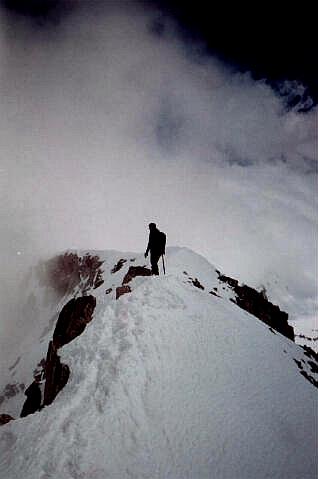
It is 7:00 a.m. and the last weekend of winter, waiting for me at the White Pine Trailhead is Milo White, my brother Todd Burrows and his friend Todd Harmon. We leave the trailhead in Little Cottonwood Canyon and begin our approach to the 11,326' Pfeifferhorn, located in Utah's Wasatch Mountains. It has not snowed for more than a week. The trail to Lower Red Pine Lake should be packed and well traveled. This is a bonus since I do not want to carry snowshoes for this adventure. I have spent many hours in front of the television this winter and need to cut weight where possible. Winter mountaineering by its very nature requires you to carry an abundance of gear, and the extra weight of snowshoes would be unwelcome. The snow is over 10 feet deep at the trailhead. As predicted the trail is packed hard, in fact, it is packed into a trail of ice. This means we are strapping on crampons within the first mile. Crampons are two-inch metal spikes, which attach to your boots. It takes us just over 2 hours to reach Lower Red Pine Lake, which is frozen solid under 15 feet of snow. The trek to Red Pine Lake is very popular in winter as a snowshoe and skiing destination. At Lower Red Pine Lake, we lose Milo to blisters and other obligations; our summit party is down to three climbers. The first serious climbing begins at Upper Red Pine Lake. We must scale the cirque headwall to gain access to Alpine Ridge. We remove our ice axes from our backpacks and watch two groups of climbers scale the cirque headwall in front of us. We also notice two climbers scaling the west ridge of 11,323' White Baldy. We begin the drudgery of surmounting Alpine Ridge. Forty feet from the ridgeline we encounter our first major obstacle. A nearly vertical, heavily corniced, ridge which requires 40 feet of climbing. We must front point with our crampons and use an ice axe on the solidly frozen snow. A fall here would probably not be deadly since there is a large run-out area at the bottom. However, a fall would presumably lead to a helicopter ride in Life Flight since that would be the only way to get an injured climber to safety. We carry an ice axe for protection against falling; an ice axe can be driven into the snow to provide a self-arrest. I worry about my brother because I know he has never practiced this technique with an ice axe, he is new to winter mountaineering. When we reach the top of the ridge, our objective comes into full view for the first time. The Pfeifferhorn is a beautifully shaped, triangular mountain, referred to as the `Little Matterhorn' because of it's striking profile. This rugged peak is buried in the isolated heart of the Lone Peak Wilderness Area. On top of the ridge, we caught up with the two groups of mountaineers who scaled the cornice in front of us. The first group was a two-man support team for the two climbers we had seen on White Baldy earlier in the morning. The climbers on White Baldy are planing on snow boarding from the summit. This would be an extreme decent, through bands of cliffs, worthy of ESPN. Unfortunately it began to snow and visibility dropped to 30 feet so we would not be witnesses to this amazing feat. The second group of four climbers were descending after viewing the next part of the Pfeifferhorn route and deciding it was beyond there expertise. We have a picture of our group taken before continuing the accent. The route along Alpine Ridge is the most dangerous part of the climb. It involves traversing a 1/4 mile long, heavily corniced, highly exposed, knife-edge ridge. The drop-off on both sides of the ridge is breathtaking. A fall here would be deadly, so each step is placed with care. In the middle of the ridge, a 15-foot rock ledge must be climbed in crampons. This obstacle it is not difficult, but it is intimidating. The visual image is surreal, as the clouds seem to boil up Little Cottonwood Canyon and spill over the ridge all around us. It has stopped snowing, but the clouds just keep streaming past. The clouds divide for a moment and the summit cone of the Pfeifferhorn is visible rising into blue sky, than the weather closes in around us again. We begin climbing the last 500 vertical feet to the summit, the going is hard, tiring and boring. We can see only several feet in front of us. Reaching the summit is anticlimactic since we are buried inside a cloud with little visibility. Lunch on a summit is always special and this time is no exception. The fog begins to lift and provide momentary views of our dramatic surroundings. We begin to down climb the summit cone. The snow has really softened as the day begins to warm up, we find ourselves sinking to our knees on south facing slopes. The knife edge traverse is not nearly as scary on the return trip, perhaps because the clouds have lifted and visibility is excellent. We reach the corniced cirque, which provides admittance to Red Pine Canyon. I start cramponing down the ice-covered cornice. I am tired from climbing all day and do not kick my crampons into the slope properly. Disaster! I slip and start what could be a 600-foot slide; I am able to self-arrest with my ice axe before sliding very far. Time to pay more attention to what I am doing and less attention to fatigue. The hike out is made difficult because the midday sun is turning the snow to slush. We find ourselves sinking past our knees in deep snow for the next mile. This requires a tiring form of travel known as post-holing. We also have to be on the lookout for small avalanches caused by the warming sun. We spread out, if one of us is caught in a slide the other two climbers must act as rescue. We finally reach the well-packed trail at Lower Red Pine Lake and the hike out becomes much easier. Eight hours after starting, we are off the mountain, completely satisfied until next weekend. For complete hiking or mountaineering information visit the Pfeifferhorn Hiking Guide. [ Homepage ] [ Introduction ] [ Warning ] [ Ratings ] [ Ethics ] [ Feedback ] [ Updates ] © Copyright 1999-, Climb-Utah.com |