[
Homepage ] [
Introduction ] [
Warning ] [
Ratings
] [ Ethics ] [
Feedback ] [
Updates ]
 |
Story Rock
Polynesian Petroglyphs
Iosepa Ghost Town
Story
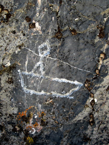
Rock is located in Skull Valley on the side of Salt Mountain above the
Polynesian ghost town of Iosepa. The petroglyphs are interesting because
they depict tropical and oceanic images. No trip to Story Rock is
complete without spending a few minutes in the Iosepa Cemetery learning
the history of the people that carved the images and settled the town. |
Circle of Friends:
Story Rock
Petroglyphs is part of the "Circle of Friends" program.
Members of the "Circle of Friends" have access to more specific information,
explicit route information, GPS waypoints, trailhead location and detailed
maps. If you would like more information on joining the "Circle of Friends"
visit the sign up page.
"Circle of Friends"
General Information:
Story Rock Petroglyphs consist of a large rock covered with Polynesian petroglyphs
and a visit to the ghost town of Iosepa. A GPS is required to
locate the Story Rock Petroglyphs. Navigation for this route is moderate. Story Rock Petroglyphs are
rated 1A I using the Canyon
Rating System.
Trailhead Information:
The trailhead is
located approximately 50 miles west of Salt Lake City and is accessible to
all vehicles in all weather conditions.
Iosepa History:
Iosepa was established in Skull Valley in 1889 as a community
for Hawaiian members of the Mormon faith who wished to immigrate to Utah to
be close to the temples and headquarters of the Church of Jesus Christ of
Latter-day Saints. Iosepa lasted as a community until 1917 at which time the
residents returned to Hawaii where the Hawaiian LDS Temple was under
construction. The LDS Church paid the travel expenses for those who could
not afford to pay themselves.
Iosepa (pronounced
"Yo-see-pa"), meaning Joseph in Hawaiian was named after the Mormon prophet
Joseph Smith. The colony was undertaken as a joint stock company
incorporated as the Iosepa Agriculture and Stock Company. The LDS Church
actually owned the company although individuals subscribed for the stock and
held it in trust for the church.
The first group of
forty-six settlers arrived on 28 August 1889 and drew lots for the land they
were to occupy. Additional settlers arrived, built houses, a schoolhouse, a
general store, and an irrigation system which drew water from the Stansbury
Mountains to water a variety of crops including beets, wheat, oats, barley,
corn, potatoes, and squash. By 1901 the population stood at about 80 and
reached 228 by 1915.
A majority of the
residents were Hawaiians, but other island groups were represented as well.
The Polynesians raised pigs and fished in local ponds to supplement the
crops they grew. A few Anglos resided in the town, working as supervisors on
the Skull Valley farm. Most residents worked small farms or were employed by
the Mormon Church farm in Skull Valley. The colony was not self-sustaining
and LDS Church leaders were forced to allocate church funds to cover
expenses. Following a series of crop failures, many of the men began to work
in the gold and silver mines which prospered in the nearby mountains during
the late 1890s.
In addition to economic
difficulties, there were other problems for the settlement. In 1896 three
cases of leprosy were discovered and the victims were isolated in a special
house, although fears of the spread of leprosy were unfounded. The harsh
environment--burning heat in the summer and extreme cold in the winter--took
its toll on the settlers, as witnessed by the large number of graves in the
cemetery.
When the Hawaiian Mormons
left Iosepa for Hawaii, many of them settled on the church plantation at
Laie, Oahu. Iosepa was sold in 1917 to a livestock company. The cemetery was
placed on the National Register of Historic Places in 1971.
[
Homepage
] [ Introduction ] [
Warning ] [
Ratings ] [
Ethics
] [ Feedback ] [
Updates ]
© Copyright
2000-, Climb-Utah.com |