[
Homepage ] [
Introduction ] [
Warning ] [
Ratings
] [ Ethics ] [
Feedback ] [
Updates ]
 |
Orderville
Gulch
Zion
National Park
Canyoneering
Orderville
Gulch is one of my favorites in Zion National Park. The canyon has as much charm as its big
brother, the Zion Narrows, with probably a little more spice.
The canyon is certainly narrower than the famous Narrows.
Orderville Gulch offers dramatic
scenery, majestic narrows, wading, short swims and a few scrambling problems to keep you
on your toes. The bonus is you can complete the canyon in time to make happy hour at the
local pub and dazzle the tourists with your tales of adventure. |
General Information:
  Orderville Gulch is a
canyoneering adventure requiring complete technical gear.
Orderville Gulch is rated 3B III using the Canyon Rating System. Every group should have at
least one experienced canyoneer or rock climber along to help defeat a few minor obstacles.
This route is suitable for novice canyoneers with competent leadership. This
route will require 7 to 8 hours to complete.
Orderville Gulch is a
canyoneering adventure requiring complete technical gear.
Orderville Gulch is rated 3B III using the Canyon Rating System. Every group should have at
least one experienced canyoneer or rock climber along to help defeat a few minor obstacles.
This route is suitable for novice canyoneers with competent leadership. This
route will require 7 to 8 hours to complete.
This route contains at least two short rappels of 20-feet or less and
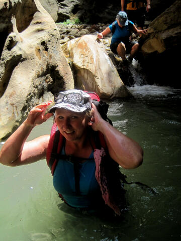
requires a 50-foot rope. Orderville Gulch requires several
miles of wading combined with a couple of possible short swims. A drybag for your gear is also suggested. The swimming is never
further than 10 to 15 feet. The water is cold and a hot day is suggested. Everyone will
want to carry a warm, dry fleece to put on if they become chilled or at the canyon end so
toss one into your drybag. During periods of cool weather a wetsuit might be
a good idea.
The difficulties in Orderville Gulch can change greatly between flash
floods. Sometimes there is no swimming and other times there is a bunch.
Sometimes the wading is minor and other times its extensive. Sometimes the
rappels can be downclimbed and sometimes they can't.
Temple of Sinawava and Clear Creek
Mountain are the USGS 7.5 minute topographical map that show Orderville Gulch. Navigation
for this adventure is easy, but there is no real trail after the first
couple of miles. All waypoints and maps for this
route use the WGS84 datum. You will be walking and wading in a canyon bottom.
You will need a Zion backcountry
permit for this canyon. Orderville Gulch has a high flash
flood danger, check the weather report at the Visitor Center when you pick up your
permit.
 |
 |
Shuttle Information:
A
vehicle shuttle is required for this adventure and cleaning up the shuttle
at the end of the day can be tedious. Cleaning up the shuttle normally
requires at least two hours on a good day. Several local companies offer
commercial shuttles for a very reasonable
price. If you value your time I suggest you at least check out the different
options.
 |
 |
Trailhead Information:
From the East
Entrance of Zion National Park, drive east 2.4 miles on highway 9. Turn
north (left) at the signed "North Fork" junction (N37° 14' 21",
W112° 49' 57"). Drive 11.5 miles (The
first 5.5 miles of road are paved) and turn west (left) on a dirt road
signed Orderville Gulch (N37° 20' 13", W112° 49' 49"). Take the dirt road west
for 0.3 miles to a large corral and a small parking lot. This is the
Orderville Gulch Trailhead and it is accessible to passenger
vehicles in dry weather conditions.
Four-wheel drive vehicles can
continue an additional 2 1/4 miles down the steep and rough dirt road. Just remember you must
retrieve your vehicle at the end of the day. Time wise it is normally faster to hike
down the steep dirt road than mess
with the four-wheel drive shuttle.
 |
 |
Route Information:
From
the Orderville Gulch Trailhead (N37° 20' 07", W112° 49' 59") follow the Four-wheel
drive road west for 2 1/4 miles, down a steep grade, and along the canyon
bottom to where the road ends. This is the optional four-wheel drive
trailhead (N37° 19' 57", W112° 51' 47").
From the four-wheel drive trailhead just continue hiking
down the canyon bottom following the trail of least resistance. After hiking
3/4 miles you will encounter a 125-foot dryfall (N37° 19' 33", W112° 52'
10"). There are
several routes around the dryfall, but the easiest is to backtrack about 150 feet and
locate a hiker made trail on the south (left) side of the canyon. The hiker made trail descends a steep dirt
slope to the canyon bottom.
From where the hiker
trail reaches the canyon bottom hike downstream 150-yards and a drainage
known as Wild Wind Hollow (N37° 19' 28", W112° 52' 14") enters from the
south (left). From Wild Wind Hollow hike downstream 1/2 mile and the
technical canyoneering route known as Birch Hollow
(N37° 19' 24", W112° 52' 33") enters from the south.
Continue hiking downstream 3/4 mile and Walker Gulch (N37° 19'
28", W112° 53' 08") enters from the north (right).
Continue hiking downstream 3/4 mile and Esplin Gulch
(N37° 19' 07", W112° 53' 47") enters from the north
(right). 1/2 mile below Esplin Gulch and you will encounter the first major
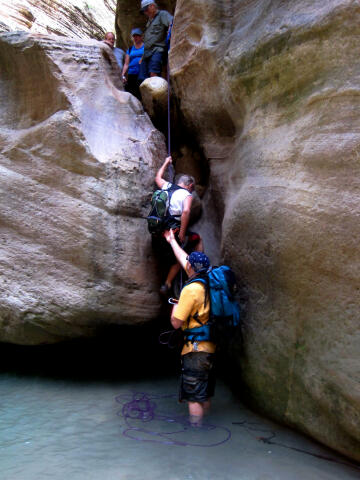
obstacle on the route. The obstacle consists of a large chokestone with a 15-foot drop on the downstream side.
The rappel anchor consists of two bolts on the north (right) wall of the
canyon. Do not jump down from this or any obstacle. Jumping is the number
one cause of search and rescues in Orderville Gulch.
300-yards below the large chokestone the technical canyoneering route known
as Englestead Hollow (N37° 18'
52", W112° 54' 22") enters from the south (left).
Continue hiking downstream for 1 3/4 miles and Bullock Gulch (N37° 18' 43",
W112° 55' 43") enters from the north (right). Bullock Gulch is where you
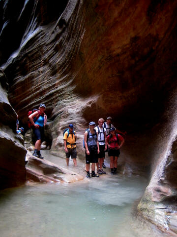
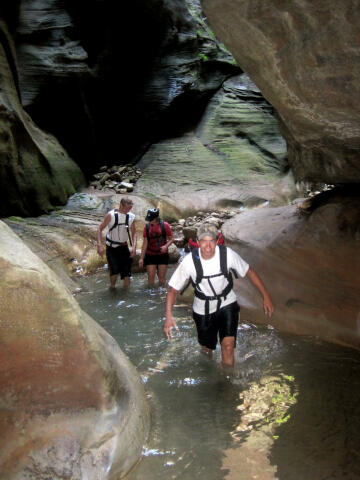
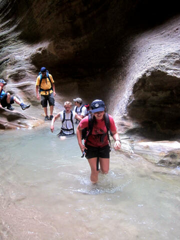
will always encounter water that will require wading for the remainder of the route.
Bulloch Gulch is also where the best section of Orderville Gulch begins.
This section is known among canyoneers as the Orderville Water Park.
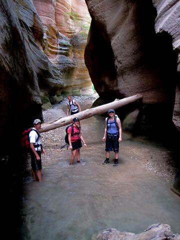
Just downstream from Bullock Gulch
the canyon offers some dramatic narrows. You will encounter a large logjam in the narrows
that you must climb over. Hand and foot holds are plentiful if you look around and
take your time. One mile below Bullock Gulch a second large chokestone with a 12-foot drop
on the downstream side presents itself. The rappel anchor consists of two
bolts on the south (left) canyon wall.
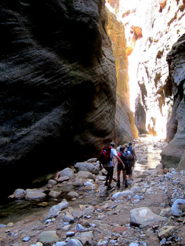
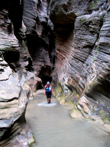
The further
down canyon you travel the more water the stream gathers from the canyon seeps. Everything
just keeps getting more exciting around every corner. The remainder of the route is made
up of short swims, small waterfalls, easy scrambles and plenty of fun. Did I forget to
mention that the narrows just keep getting better around every bend?
3/4 miles below the
second large chokestone you will encounter the
dramatic confluence of Orderville Gulch and the Zion Narrows
(N37° 18' 28", W112° 56' 48"), which enter from the north (right). The
confluence is very dramatic. At
the confluence with the Zion Narrows just keep hiking downstream. You should
meet dozens of tourists for the remainder of the route who have hiked up canyon.
After hiking down the Narrows for 1 1/4 miles you will encounter an
attention-grabbing 115-foot waterfall on the east (left) canyon wall. This
is Mystery Falls (N37° 17' 57", W112° 56' 40")
and is also the exit of the popular technical canyoneering
route known as Mystery Canyon .
From Mystery Falls it is a 1/2 mile hike downstream to where the paved
tourist trail begins (N37° 17' 37", W112° 56' 50"). When you
encounter the paved tourist trail just follow it downstream for an
additional 1/2 mile to the Temple of the Sinawava (N37° 17' 07", W112° 56'
52") and the shuttle bus.
Video:
Anyone considering
canyoneering Orderville Gulch for the first time should watch the video to
get an idea of what you are in for. If you are an Orderville Gulch veteran
just sit back and enjoy the show.
If this video fails to play on your mobile device or computer you can always
watch the Original
YouTube Version here.
[
Homepage
] [ Introduction ] [
Warning ] [
Ratings ] [
Ethics
] [ Feedback ] [
Updates ]
© Copyright
2000-, Climb-Utah.com |