[ Homepage ] [ Introduction ] [ Warning ] [ Ratings
] [ Ethics ] [ Feedback ] [ Updates
]
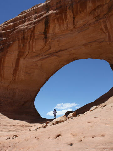 |
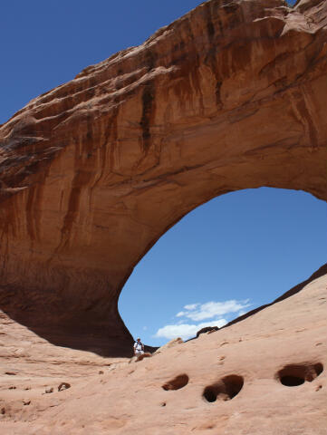
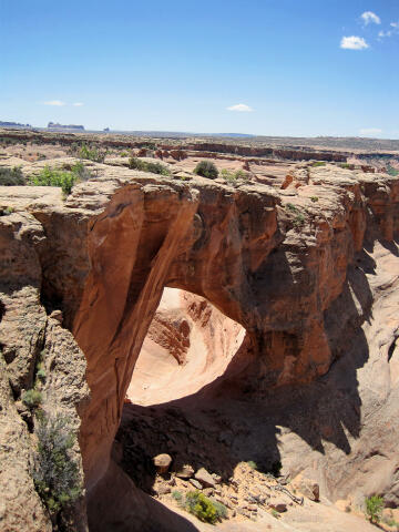
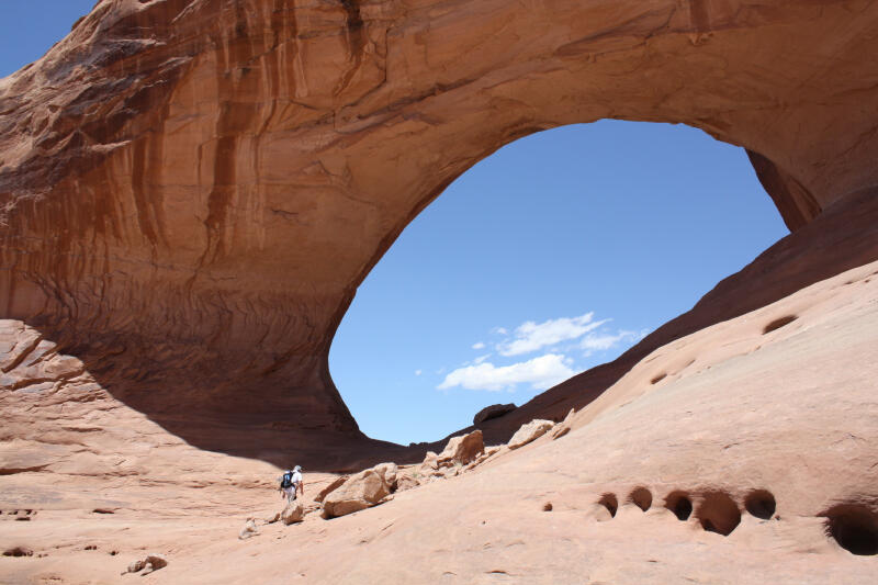
Covert Arch
Arches National Park
Arch Hunting
Covert Arch is located in the Lost Springs Canyon section of Arches
National Park. This is a remote area appropriate for those seeking seclusion
from the typical tourist type crowd. Covert Arch is extremely
impressive. |
General Information:
  Covert Arch is located in a remote section of Arches National Park that
contains dramatic scenery. There are no trails or signs in this area. The
route is suitable for intermediate or experienced hikers. Total time required
for a round trip is approximately 3 hours, depending on how much time you
spend exploring the area. Undercover Canyon is rated 2A II using the Canyon
Rating System.
Covert Arch is located in a remote section of Arches National Park that
contains dramatic scenery. There are no trails or signs in this area. The
route is suitable for intermediate or experienced hikers. Total time required
for a round trip is approximately 3 hours, depending on how much time you
spend exploring the area. Undercover Canyon is rated 2A II using the Canyon
Rating System.
Much of the route is exposed to the sun and there is little shade available.
Every member of your hiking party should carry at least one liter of water. This
arch is accessible year round. The route would not be at it's
best during the hot summer month's. This is an excellent cool weather
adventure.
Navigation
for this route is moderate. A GPS is extremely useful. Good map reading
skills and the USGS 7.5' Maps titled "Cisco SW" and "Mollie Hogans" are essential. All waypoints and maps
use the WGS84 datum.
Arch
hunters will be happy to note that this trip combines well with a visit to
La Boca Arch.
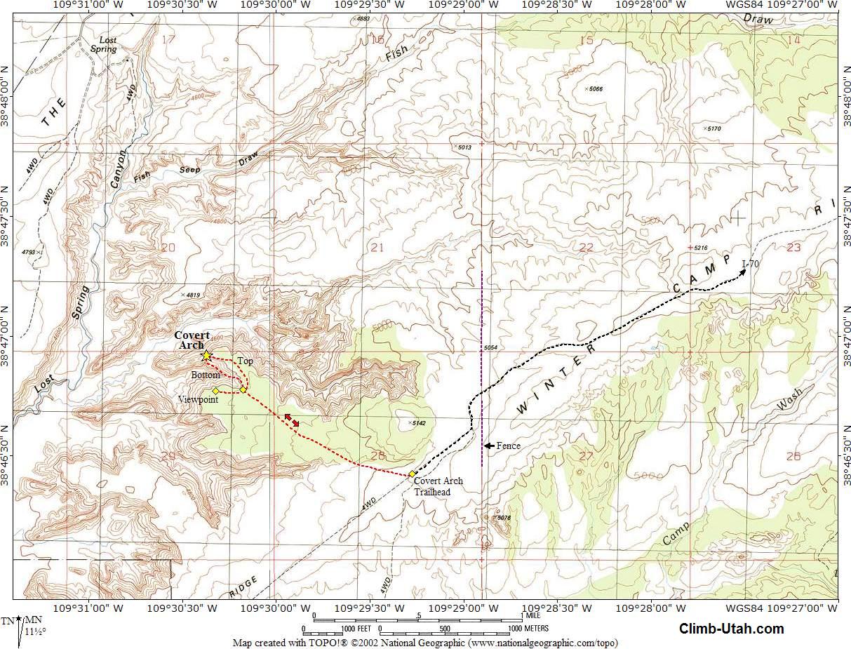
Trailhead Information:
While this route is
located inside Arches National Park it's a long drive to the trailhead
because the route is located on the backside of Arches National Park. A four
wheel drive is recommended as the roads are often covered with blow sand.
The roads are not hardcore four wheeling, but you might encounter short
sandy sections in normal driving conditions. The area is criss-crossed with
roads. Stay on the road described until told to turn off of it.
From Green River, Utah: Travel east for 18 miles to Crescent Junction
(where I-70 meets Highway 191).
From Moab, Utah: Travel north on Highway 191 for 30 miles to Crescent
Junction (where I-70 meets Highway 191).
From Crescent Junction: Follow I-70 east for 11 miles to Exit 193
(N38° 56' 32", W109° 36' 53"), signed Yellow Cat. Exit I-70 and turn south.
Follow the graded Yellow Cat Road southeast for 6.2 miles to a fork (N38°
52' 04", W109° 33' 00"). Take the east (left) fork. Continue following the
road for 2.1 miles to the Yellow Cat Mine Ruins (N38° 50' 53", W109° 31'
42"). The ruins are located on the east side of the road.
From The Yellow Cat Mine Ruins follow the road east for 1.0 mile to a fork
(N38° 51' 01", W109° 30' 38"). Take the south (right) fork and
follow the road 2.6 miles to a fork
(N38° 49' 27", W109° 29' 48"). Take the east (left) fork and follow the road
3.1 miles to a junction (N38° 48' 31", W109° 26' 53"). Take the south
(right) fork and follow the road 1.2 miles to a junction (N38° 47' 51",
W109° 26' 06"), with a less traveled road heading west (right).
Carefully driven passenger vehicles and high clearance vehicles can normally
reach this junction without problems, beyond this point the roads might
contain sections of deep sand.
Follow the less traveled road west for 3.1 miles to a fork (N38° 46' 37",
W109° 28' 57"). Take the west (right) fork and follow the road for 0.3
miles. This is the Covert Arch Trailhead. There is nothing to identify the
trailhead other than the road is at the crest of a small rise. Pull off the
road where it is convenet.
Route Information:
From the
Covert Arch Trailhead (N38°
46' 26", W109° 29' 16"), start hiking northwest. You will cross a
wash just after leaving the trailhead and hike for approximately 1 mile
cross-country. Those with good navigation skills or a GPS will arrive at the
head of an impressive canyon (N38° 46' 47", W109° 30' 11"). From the
head of the canyon Covert Arch (N38° 46' 55", W109° 30' 22") should be
visible just under the rim if you look northwest.
From the head of the canyon you have three great options.
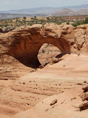
Option 1 - Viewpoint
To get a great view of Covert Arch without having to scramble, hike
200-yards around the south side of the canyon to a
really nice viewpoint (N38° 46' 46", W109°
30' 19"). This is the best view of the arch for those
that do not intend to scramble through the arch.
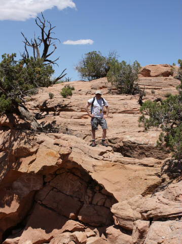
Option 2 - Over the Top
If you want to stand on top of Covert Arch hike 1/4 mile around the
north side of the canyon and out onto an amazing peninsula between
two deep canyons that form the arch. It's easy to walk
right over the top of the arch and completely miss it if you are not
paying attention to its location. All true arch baggers know that
you must stand on top of the arch to count it among your
accomplishments.
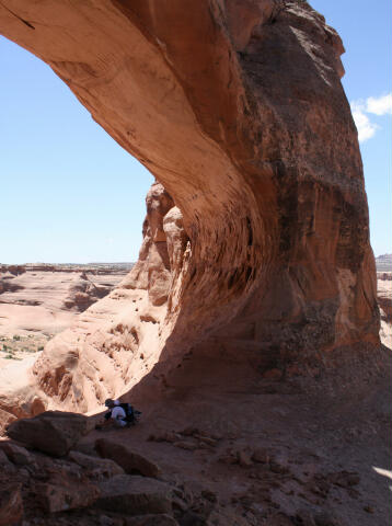
Option 3: Through the Center
Scrambling through the arch is the must do route for the
adventurous. To scramble through the arch begin hiking around the
north side of the canyon, after approximately 100-yards you will
reach a weakness in the rim that allows you to scramble down one
layer of sandstone and then contour northwest to just below the base
of Covert Arch. Scramble up into the center of the arch.
Mix and match the options to suit your desires, or enjoy the full meal deal.
Return the way you came.
Covert Arch Statistics:
Greater Arch Dimension (GAD): 60 feet. For this arch, the LAD is its span.
Lesser Arch Dimension (LAD): 32 feet. For this arch, the GAD is its height.
Arch Type: Shelter
Rock formation and/or type: Navajo Sandstone
History:
The 3,140-acres of Lost
Spring Canyon were added to Arches National Park in 1998. The area provides
a unique backcountry experience. Since 1985 the Bureau of Land Management
had administered the area as a Wilderness Study Area. When Lost Spring
Canyon was added to Arches, the Grand Canyon Trust generously purchased the
grazing permits and donated them to the National Park Service. Livestock has
been removed and is now fenced out improving the backcountry experience.
[ Homepage
] [ Introduction ] [ Warning ] [ Ratings ] [ Ethics
] [ Feedback ] [ Updates ]
© Copyright
2000-, Climb-Utah.com |